Fountain Hills geodata
Fountain Hills (Arizona) is a populated place; located in United States in America/Phoenix (GMT-7) time zone. With population of 23,899 people, there are 2116 cities with bigger population in this country. Compared to other cities in United States, 82.5% of cities are located further ↑North; 86.8% of cities are located further →East and 87.7% of cities have lower elevation than Fountain Hills. Note1


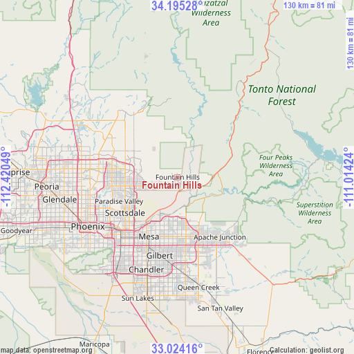
Fountain Hills GPS coordinates[2]
33° 36' 42.156" North, 111° 43' 2.496" West
| Map corner | latitude | longitude |
|---|---|---|
| Upper-left | 34.19528°, | -112.42049° |
| Center: | 33.61171°, | -111.71736° |
| Lower-right: | 33.02416°, | -111.01424° |
| Map W x H: | 130.2×130.2 km | = 80.9×80.9mi |
| max Lat: | 71.29058° ⇑82.5% North |
| Fountain Hills: | 33.61171° |
| min Lat: | ⇓17.5% South 19.06759° |
| min Long | Fountain Hills | max Long |
| -171.73463° | -111.71736° | -66.98998° |
| W 13.2%⇐ | ⇒86.8% E |
Elevation
Elevation of Fountain Hills is 494 m = 1621 ft, and this is 199.2 m = 654 ft above average elevation for this country.
| Max E: |
3189 m = 10463 ft | 12.3% |
| Fountain Hills | 494 m 1621 ft | |
| Avg. | 294.8 m = 967 ft | |
Min E: |
-60 m = -197 ft | 87.7% |
See also: United States elevation on elevation.city.
Geographical zone
Fountain Hills is located in North temperate zone (between Tropic of Cancer and the Arctic Circle). Distance of this Northern Tropic circle is 1131.4 km =703 mi to South.| Distance of | km | miles | from Fountain Hills |
|---|---|---|---|
| North Pole | 6269.8 | 3895.9 | to North |
| Arctic Circle | 3663.9 | 2276.6 | to North |
| Tropic Cancer | 1131.4 | 703 | to South |
| Equator | 3737.3 | 2322.2 | to South |


Nearby cities:
15 places around Fountain Hills: (largest is in red/bold)
• Apache Junction
26.8 km =16.7 mi,  144°
144°
• Carefree
29.9 km =18.6 mi,  321°
321°
• Cave Creek
32.8 km =20.4 mi, 318°
• Central City
36.9 km =22.9 mi,  238°
238°
• Chandler
35.9 km =22.3 mi,  198°
198°
• Encanto
36.5 km =22.7 mi,  246°
246°
• Gilbert
29.5 km =18.3 mi,  193°
193°
• Guadalupe
35.2 km =21.9 mi,  220°
220°
• Mesa
23.2 km =14.4 mi, 204°
• Paradise Valley
22.7 km =14.1 mi, 246°
• Rio Verde
12.9 km =8 mi,  17°
17°
• San Carlos
32 km =19.9 mi, 202°
• Scottsdale
20.3 km =12.6 mi, 235°
• Tempe
28.2 km =17.5 mi, 219°
• Tempe Junction
30.4 km =18.9 mi, 223°
Sources, notices
• [Note1] Compared only with cities in United States existing in our database
• [Src1] Map data: © OpenStreetMap contributors (CC-BY-SA)
• [Src2] Other city data from geonames.org with taken over terms of usage.
• [Src3] Geographical zone / Annual Mean Temperature by Robert A. Rohde @ Wikipedia
