Gilbert geodata
Gilbert (Arizona) is a populated place; located in United States in America/Phoenix (GMT-7) time zone. With population of 247,542 people, there are 93 cities with bigger population in this country. Compared to other cities in United States, 83.8% of cities are located further ↑North; 86.9% of cities are located further →East and 82.1% of cities have lower elevation than Gilbert. Note1


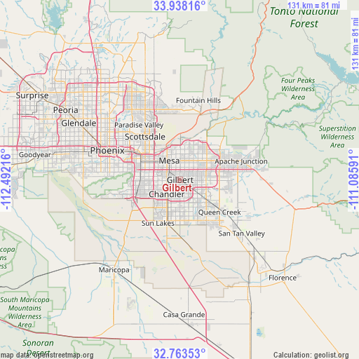
Gilbert GPS coordinates[2]
33° 21' 10.188" North, 111° 47' 20.508" West
| Map corner | latitude | longitude |
|---|---|---|
| Upper-left | 33.93816°, | -112.49216° |
| Center: | 33.35283°, | -111.78903° |
| Lower-right: | 32.76353°, | -111.08591° |
| Map W x H: | 130.6×130.6 km | = 81.2×81.2mi |
| max Lat: | 71.29058° ⇑83.8% North |
| Gilbert: | 33.35283° |
| min Lat: | ⇓16.2% South 19.06759° |
| min Long | Gilbert | max Long |
| -171.73463° | -111.78903° | -66.98998° |
| W 13.1%⇐ | ⇒86.9% E |
Elevation
Elevation of Gilbert is 377 m = 1237 ft, and this is 82.2 m = 270 ft above average elevation for this country.
| Max E: |
3189 m = 10463 ft | 17.9% |
| Gilbert | 377 m 1237 ft | |
| Avg. | 294.8 m = 967 ft | |
Min E: |
-60 m = -197 ft | 82.1% |
See also: Gilbert elevation on elevation.city.
Geographical zone
Gilbert is located in North temperate zone (between Tropic of Cancer and the Arctic Circle). Distance of this Northern Tropic circle is 1102.6 km =685.1 mi to South.| Distance of | km | miles | from Gilbert |
|---|---|---|---|
| North Pole | 6298.6 | 3913.8 | to North |
| Arctic Circle | 3692.7 | 2294.5 | to North |
| Tropic Cancer | 1102.6 | 685.1 | to South |
| Equator | 3708.5 | 2304.4 | to South |


Nearby cities:
15 places around Gilbert: (largest is in red/bold)
• Ahwatukee Foothills
18.2 km =11.3 mi,  266°
266°
• Apache Junction
23.3 km =14.5 mi,  72°
72°
• Casa Blanca
27.4 km =17 mi,  199°
199°
• Central City
26.8 km =16.7 mi,  291°
291°
• Chandler
7.1 km =4.4 mi,  223°
223°
• Guadalupe
16.3 km =10.1 mi,  277°
277°
• Mesa
8.3 km =5.2 mi,  337°
337°
• Paradise Valley
24.4 km =15.2 mi,  324°
324°
• Queen Creek
18.5 km =11.5 mi,  128°
128°
• San Carlos
5.8 km =3.6 mi,  262°
262°
• Santan
19.7 km =12.2 mi,  182°
182°
• Scottsdale
20.2 km =12.6 mi,  329°
329°
• Sun Lakes
17.7 km =11 mi,  207°
207°
• Tempe
13.1 km =8.1 mi,  301°
301°
• Tempe Junction
15.9 km =9.9 mi, 295°
Sources, notices
• [Note1] Compared only with cities in United States existing in our database
• [Src1] Map data: © OpenStreetMap contributors (CC-BY-SA)
• [Src2] Other city data from geonames.org with taken over terms of usage.
• [Src3] Geographical zone / Annual Mean Temperature by Robert A. Rohde @ Wikipedia
