San Carlos geodata
San Carlos (Arizona) is a populated place; located in United States in America/Phoenix (GMT-7) time zone. With population of 4,103 people, there are 8089 cities with bigger population in this country. Compared to other cities in United States, 83.8% of cities are located further ↑North; 87.1% of cities are located further →East and 81.2% of cities have lower elevation than San Carlos. Note1


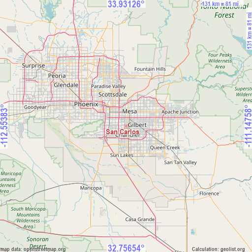
San Carlos GPS coordinates[2]
33° 20' 45.168" North, 111° 51' 2.52" West
| Map corner | latitude | longitude |
|---|---|---|
| Upper-left | 33.93126°, | -112.55383° |
| Center: | 33.34588°, | -111.8507° |
| Lower-right: | 32.75654°, | -111.14758° |
| Map W x H: | 130.6×130.6 km | = 81.2×81.2mi |
| max Lat: | 71.29058° ⇑83.8% North |
| San Carlos: | 33.34588° |
| min Lat: | ⇓16.2% South 19.06759° |
| min Long | San Carlos | max Long |
| -171.73463° | -111.8507° | -66.98998° |
| W 12.9%⇐ | ⇒87.1% E |
Elevation
Elevation of San Carlos is 367 m = 1204 ft, and this is 72.2 m = 237 ft above average elevation for this country.
| Max E: |
3189 m = 10463 ft | 18.8% |
| San Carlos | 367 m 1204 ft | |
| Avg. | 294.8 m = 967 ft | |
Min E: |
-60 m = -197 ft | 81.2% |
See also: United States elevation on elevation.city.
Geographical zone
San Carlos is located in North temperate zone (between Tropic of Cancer and the Arctic Circle). Distance of this Northern Tropic circle is 1101.8 km =684.6 mi to South.| Distance of | km | miles | from San Carlos |
|---|---|---|---|
| North Pole | 6299.3 | 3914.2 | to North |
| Arctic Circle | 3693.5 | 2295 | to North |
| Tropic Cancer | 1101.8 | 684.6 | to South |
| Equator | 3707.7 | 2303.9 | to South |


Nearby cities:
15 places around San Carlos: (largest is in red/bold)
• Ahwatukee Foothills
12.4 km =7.7 mi,  267°
267°
• Casa Blanca
25.3 km =15.7 mi,  187°
187°
• Central City
21.9 km =13.6 mi,  298°
298°
• Chandler
4.5 km =2.8 mi,  168°
168°
• Gilbert
5.8 km =3.6 mi,  82°
82°
• Guadalupe
10.8 km =6.7 mi,  284°
284°
• Mesa
8.9 km =5.5 mi,  17°
17°
• Paradise Valley
22.3 km =13.9 mi,  337°
337°
• Phoenix
23.7 km =14.7 mi, 298°
• Queen Creek
22.8 km =14.2 mi,  118°
118°
• Santan
19.5 km =12.1 mi, 165°
• Scottsdale
18.7 km =11.6 mi,  346°
346°
• Sun Lakes
15.2 km =9.4 mi, 188°
• Tempe
9.4 km =5.8 mi,  324°
324°
• Tempe Junction
11.5 km =7.1 mi,  311°
311°
Sources, notices
• [Note1] Compared only with cities in United States existing in our database
• [Src1] Map data: © OpenStreetMap contributors (CC-BY-SA)
• [Src2] Other city data from geonames.org with taken over terms of usage.
• [Src3] Geographical zone / Annual Mean Temperature by Robert A. Rohde @ Wikipedia
