Scottsdale geodata
Scottsdale (Arizona) is a populated place; located in United States in America/Phoenix (GMT-7) time zone. With population of 236,839 people, there are 101 cities with bigger population in this country. Compared to other cities in United States, 83.1% of cities are located further ↑North; 87.2% of cities are located further →East and 82.5% of cities have lower elevation than Scottsdale. Note1


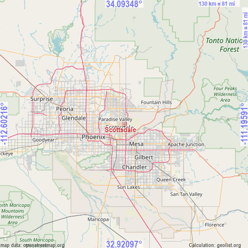
Scottsdale GPS coordinates[2]
33° 30' 33.156" North, 111° 53' 56.508" West
| Map corner | latitude | longitude |
|---|---|---|
| Upper-left | 34.09348°, | -112.60216° |
| Center: | 33.50921°, | -111.89903° |
| Lower-right: | 32.92097°, | -111.19591° |
| Map W x H: | 130.4×130.4 km | = 81×81mi |
| max Lat: | 71.29058° ⇑83.1% North |
| Scottsdale: | 33.50921° |
| min Lat: | ⇓16.9% South 19.06759° |
| min Long | Scottsdale | max Long |
| -171.73463° | -111.89903° | -66.98998° |
| W 12.8%⇐ | ⇒87.2% E |
Elevation
Elevation of Scottsdale is 382 m = 1253 ft, and this is 87.2 m = 286 ft above average elevation for this country.
| Max E: |
3189 m = 10463 ft | 17.5% |
| Scottsdale | 382 m 1253 ft | |
| Avg. | 294.8 m = 967 ft | |
Min E: |
-60 m = -197 ft | 82.5% |
See also: Scottsdale elevation on elevation.city.
Geographical zone
Scottsdale is located in North temperate zone (between Tropic of Cancer and the Arctic Circle). Distance of this Northern Tropic circle is 1120 km =695.9 mi to South.| Distance of | km | miles | from Scottsdale |
|---|---|---|---|
| North Pole | 6281.2 | 3903 | to North |
| Arctic Circle | 3675.3 | 2283.7 | to North |
| Tropic Cancer | 1120 | 695.9 | to South |
| Equator | 3725.9 | 2315.2 | to South |


Nearby cities:
15 places around Scottsdale: (largest is in red/bold)
• Ahwatukee Foothills
20.2 km =12.6 mi,  202°
202°
• Alhambra
21.8 km =13.5 mi,  266°
266°
• Central City
16.6 km =10.3 mi,  242°
242°
• Chandler
23.2 km =14.4 mi,  166°
166°
• Encanto
16.9 km =10.5 mi,  258°
258°
• Fountain Hills
20.3 km =12.6 mi,  55°
55°
• Gilbert
20.2 km =12.6 mi,  149°
149°
• Guadalupe
16.5 km =10.3 mi, 201°
• Maryvale
25.8 km =16 mi, 268°
• Mesa
12 km =7.5 mi,  143°
143°
• Paradise Valley
4.7 km =2.9 mi,  301°
301°
• Phoenix
17.6 km =10.9 mi,  247°
247°
• San Carlos
18.7 km =11.6 mi, 166°
• Tempe
10.5 km =6.5 mi,  185°
185°
• Tempe Junction
11.3 km =7 mi, 201°
Sources, notices
• [Note1] Compared only with cities in United States existing in our database
• [Src1] Map data: © OpenStreetMap contributors (CC-BY-SA)
• [Src2] Other city data from geonames.org with taken over terms of usage.
• [Src3] Geographical zone / Annual Mean Temperature by Robert A. Rohde @ Wikipedia
