Grand Canyon geodata
Grand Canyon (Arizona) is a populated place; located in United States in America/Phoenix (GMT-7) time zone. With population of 1,460 people, there are 13839 cities with bigger population in this country. Compared to other cities in United States, 70.2% of cities are located further ↑North; 87.8% of cities are located further →East and 99.4% of cities have lower elevation than Grand Canyon. Note1


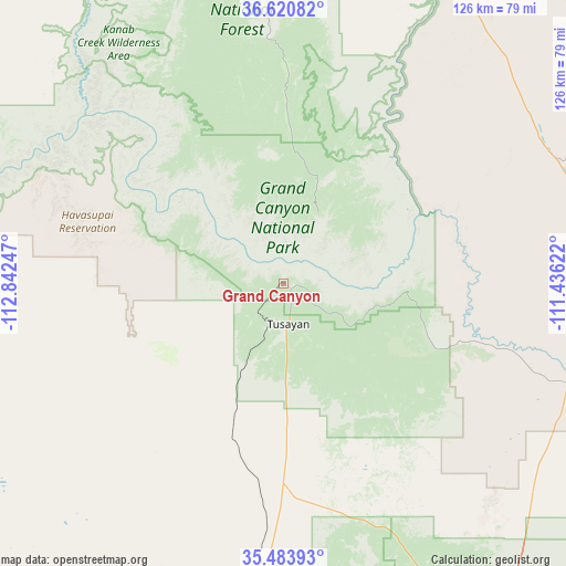
Grand Canyon GPS coordinates[2]
36° 3' 15.948" North, 112° 8' 21.624" West
| Map corner | latitude | longitude |
|---|---|---|
| Upper-left | 36.62082°, | -112.84247° |
| Center: | 36.05443°, | -112.13934° |
| Lower-right: | 35.48393°, | -111.43622° |
| Map W x H: | 126.4×126.4 km | = 78.5×78.5mi |
| max Lat: | 71.29058° ⇑70.2% North |
| Grand Canyon: | 36.05443° |
| min Lat: | ⇓29.8% South 19.06759° |
| min Long | Grand Canyon | max Long |
| -171.73463° | -112.13934° | -66.98998° |
| W 12.2%⇐ | ⇒87.8% E |
Elevation
Elevation of Grand Canyon is 2105 m = 6906 ft, and this is 1810.2 m = 5939 ft above average elevation for this country.
| Max E: |
3189 m = 10463 ft | 0.59999999999999% |
| Grand Canyon | 2105 m 6906 ft | |
| Avg. | 294.8 m = 967 ft | |
Min E: |
-60 m = -197 ft | 99.4% |
See also: United States elevation on elevation.city.
Geographical zone
Grand Canyon is located in North temperate zone (between Tropic of Cancer and the Arctic Circle). Distance of this Northern Tropic circle is 1403 km =871.8 mi to South.| Distance of | km | miles | from Grand Canyon |
|---|---|---|---|
| North Pole | 5998.2 | 3727.1 | to North |
| Arctic Circle | 3392.3 | 2107.9 | to North |
| Tropic Cancer | 1403 | 871.8 | to South |
| Equator | 4008.9 | 2491 | to South |


Nearby cities:
15 places around Grand Canyon: (largest is in red/bold)
• Cameron
68.3 km =42.4 mi,  106°
106°
• Flagstaff
104.9 km =65.2 mi,  155°
155°
• Fredonia
105 km =65.2 mi,  340°
340°
• Grand Canyon Village
1.6 km =1 mi,  235°
235°
• Kachina Village
113.9 km =70.8 mi, 159°
• Kaibito
112.9 km =70.2 mi,  57°
57°
• LeChee
109.4 km =68 mi,  34°
34°
• Moenkopi
82.6 km =51.3 mi,  85°
85°
• Page
113.5 km =70.5 mi, 32°
• Parks
89.9 km =55.9 mi,  168°
168°
• Tonalea
109.6 km =68.1 mi,  74°
74°
• Tuba City
81.3 km =50.5 mi,  83°
83°
• Tusayan
9.1 km =5.7 mi, 172°
• Valle
44.6 km =27.7 mi,  179°
179°
• Williams
89.6 km =55.7 mi, 182°
Sources, notices
• [Note1] Compared only with cities in United States existing in our database
• [Src1] Map data: © OpenStreetMap contributors (CC-BY-SA)
• [Src2] Other city data from geonames.org with taken over terms of usage.
• [Src3] Geographical zone / Annual Mean Temperature by Robert A. Rohde @ Wikipedia
