Parks geodata
Parks (Arizona) is a populated place; located in United States in America/Phoenix (GMT-7) time zone. With population of 1,188 people, there are 15190 cities with bigger population in this country. Compared to other cities in United States, 73.9% of cities are located further ↑North; 87.4% of cities are located further →East and 99.6% of cities have lower elevation than Parks. Note1


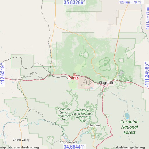
Parks GPS coordinates[2]
35° 15' 38.052" North, 111° 56' 55.572" West
| Map corner | latitude | longitude |
|---|---|---|
| Upper-left | 35.83266°, | -112.6519° |
| Center: | 35.26057°, | -111.94877° |
| Lower-right: | 34.68441°, | -111.24565° |
| Map W x H: | 127.7×127.7 km | = 79.3×79.3mi |
| max Lat: | 71.29058° ⇑73.9% North |
| Parks: | 35.26057° |
| min Lat: | ⇓26.1% South 19.06759° |
| min Long | Parks | max Long |
| -171.73463° | -111.94877° | -66.98998° |
| W 12.6%⇐ | ⇒87.4% E |
Elevation
Elevation of Parks is 2167 m = 7110 ft, and this is 1872.2 m = 6142 ft above average elevation for this country.
| Max E: |
3189 m = 10463 ft | 0.40000000000001% |
| Parks | 2167 m 7110 ft | |
| Avg. | 294.8 m = 967 ft | |
Min E: |
-60 m = -197 ft | 99.6% |
See also: United States elevation on elevation.city.
Geographical zone
Parks is located in North temperate zone (between Tropic of Cancer and the Arctic Circle). Distance of this Northern Tropic circle is 1314.7 km =816.9 mi to South.| Distance of | km | miles | from Parks |
|---|---|---|---|
| North Pole | 6086.5 | 3782 | to North |
| Arctic Circle | 3480.6 | 2162.7 | to North |
| Tropic Cancer | 1314.7 | 816.9 | to South |
| Equator | 3920.6 | 2436.1 | to South |


Nearby cities:
15 places around Parks: (largest is in red/bold)
• Big Park
56 km =34.8 mi,  162°
162°
• Clarkdale
55.3 km =34.4 mi,  190°
190°
• Cornville
60.4 km =37.5 mi,  177°
177°
• Cottonwood
58.2 km =36.2 mi, 185°
• Flagstaff
27.9 km =17.3 mi,  104°
104°
• Kachina Village
29.5 km =18.3 mi,  128°
128°
• Mountainaire
32.3 km =20.1 mi, 127°
• Munds Park
44.9 km =27.9 mi,  141°
141°
• Paulden
63 km =39.1 mi,  228°
228°
• Sedona
46.7 km =29 mi, 158°
• Valle
47 km =29.2 mi,  338°
338°
• Verde Village
61.4 km =38.2 mi, 185°
• Village of Oak Creek (Big Park)
56 km =34.8 mi, 162°
• West Sedona
45.6 km =28.3 mi, 163°
• Williams
22 km =13.7 mi,  266°
266°
Sources, notices
• [Note1] Compared only with cities in United States existing in our database
• [Src1] Map data: © OpenStreetMap contributors (CC-BY-SA)
• [Src2] Other city data from geonames.org with taken over terms of usage.
• [Src3] Geographical zone / Annual Mean Temperature by Robert A. Rohde @ Wikipedia
