Flagstaff geodata
Flagstaff (Arizona) is a seat of a second-order administrative division; located in United States in America/Phoenix (GMT-7) time zone. With population of 70,320 people, there are 592 cities with bigger population in this country. Compared to other cities in United States, 74.3% of cities are located further ↑North; 86.7% of cities are located further →East and 99.4% of cities have lower elevation than Flagstaff. Note1


Flagstaff GPS coordinates[2]
35° 11' 53.052" North, 111° 39' 4.572" West
| Map corner | latitude | longitude |
|---|---|---|
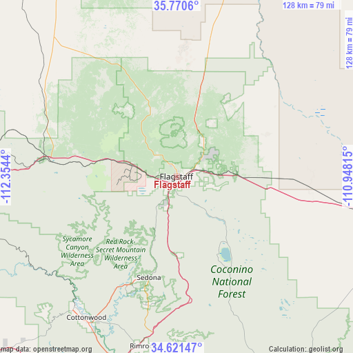
| Upper-left | 35.7706°, | -112.3544° |
| Center: | 35.19807°, | -111.65127° |
| Lower-right: | 34.62147°, | -110.94815° |
| Map W x H: | 127.8×127.8 km | = 79.4×79.4mi |
| max Lat: | 71.29058° ⇑74.3% North |
| Flagstaff: | 35.19807° |
| min Lat: | ⇓25.7% South 19.06759° |
| min Long | Flagstaff | max Long |
| -171.73463° | -111.65127° | -66.98998° |
| W 13.3%⇐ | ⇒86.7% E |
Elevation
Elevation of Flagstaff is 2108 m = 6916 ft, and this is 1813.2 m = 5949 ft above average elevation for this country.
| Max E: |
3189 m = 10463 ft | 0.59999999999999% |
| Flagstaff | 2108 m 6916 ft | |
| Avg. | 294.8 m = 967 ft | |
Min E: |
-60 m = -197 ft | 99.4% |
See also: Flagstaff elevation on elevation.city.
Geographical zone
Flagstaff is located in North temperate zone (between Tropic of Cancer and the Arctic Circle). Distance of this Northern Tropic circle is 1307.7 km =812.6 mi to South.| Distance of | km | miles | from Flagstaff |
|---|---|---|---|
| North Pole | 6093.4 | 3786.3 | to North |
| Arctic Circle | 3487.5 | 2167 | to North |
| Tropic Cancer | 1307.7 | 812.6 | to South |
| Equator | 3913.7 | 2431.9 | to South |


Nearby cities:
15 places around Flagstaff: (largest is in red/bold)
• Big Park
47.5 km =29.5 mi,  192°
192°
• Clarkdale
60.2 km =37.4 mi,  217°
217°
• Cornville
58.8 km =36.5 mi,  204°
204°
• Cottonwood
60.6 km =37.7 mi,  212°
212°
• Kachina Village
11.9 km =7.4 mi, 198°
• Lake Montezuma
64 km =39.8 mi, 190°
• Leupp
59.6 km =37 mi,  79°
79°
• Mountainaire
12.6 km =7.8 mi, 186°
• Munds Park
28.1 km =17.5 mi,  177°
177°
• Parks
27.9 km =17.3 mi,  284°
284°
• Sedona
37.8 km =23.5 mi, 195°
• Verde Village
63.4 km =39.4 mi, 211°
• Village of Oak Creek (Big Park)
47.5 km =29.5 mi, 192°
• West Sedona
39.4 km =24.5 mi, 200°
• Williams
49.4 km =30.7 mi, 276°
Sources, notices
• [Note1] Compared only with cities in United States existing in our database
• [Src1] Map data: © OpenStreetMap contributors (CC-BY-SA)
• [Src2] Other city data from geonames.org with taken over terms of usage.
• [Src3] Geographical zone / Annual Mean Temperature by Robert A. Rohde @ Wikipedia
