Page geodata
Page (Arizona) is a populated place; located in United States in America/Phoenix (GMT-7) time zone. With population of 7,490 people, there are 5544 cities with bigger population in this country. Compared to other cities in United States, 66.5% of cities are located further ↑North; 86.6% of cities are located further →East and 95.4% of cities have lower elevation than Page. Note1


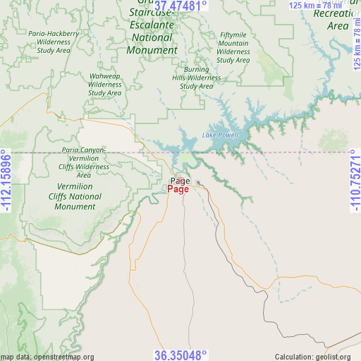
Page GPS coordinates[2]
36° 54' 52.992" North, 111° 27' 20.988" West
| Map corner | latitude | longitude |
|---|---|---|
| Upper-left | 37.47481°, | -112.15896° |
| Center: | 36.91472°, | -111.45583° |
| Lower-right: | 36.35048°, | -110.75271° |
| Map W x H: | 125×125 km | = 77.7×77.7mi |
| max Lat: | 71.29058° ⇑66.5% North |
| Page: | 36.91472° |
| min Lat: | ⇓33.5% South 19.06759° |
| min Long | Page | max Long |
| -171.73463° | -111.45583° | -66.98998° |
| W 13.4%⇐ | ⇒86.6% E |
Elevation
Elevation of Page is 1327 m = 4354 ft, and this is 1032.2 m = 3386 ft above average elevation for this country.
| Max E: |
3189 m = 10463 ft | 4.6% |
| Page | 1327 m 4354 ft | |
| Avg. | 294.8 m = 967 ft | |
Min E: |
-60 m = -197 ft | 95.4% |
See also: United States elevation on elevation.city.
Geographical zone
Page is located in North temperate zone (between Tropic of Cancer and the Arctic Circle). Distance of this Northern Tropic circle is 1498.6 km =931.2 mi to South.| Distance of | km | miles | from Page |
|---|---|---|---|
| North Pole | 5902.5 | 3667.6 | to North |
| Arctic Circle | 3296.6 | 2048.4 | to North |
| Tropic Cancer | 1498.6 | 931.2 | to South |
| Equator | 4104.5 | 2550.4 | to South |


Nearby cities:
15 places around Page: (largest is in red/bold)
• Escalante
96 km =59.7 mi,  352°
352°
• Fredonia
95.2 km =59.2 mi,  272°
272°
• Grand Canyon
113.5 km =70.5 mi,  212°
212°
• Grand Canyon Village
115 km =71.5 mi, 212°
• Kaibito
49 km =30.4 mi,  136°
136°
• Kanab
96.2 km =59.8 mi,  278°
278°
• Kayenta
108.9 km =67.7 mi,  101°
101°
• LeChee
6 km =3.7 mi,  166°
166°
• Moenkopi
91.8 km =57 mi, 166°
• Oljato-Monument Valley
107.8 km =67 mi,  83°
83°
• Orderville
112.2 km =69.7 mi,  290°
290°
• Shonto
80.7 km =50.1 mi,  116°
116°
• Tonalea
79.2 km =49.2 mi,  146°
146°
• Tropic
96.5 km =60 mi,  324°
324°
• Tuba City
88.8 km =55.2 mi, 167°
Sources, notices
• [Note1] Compared only with cities in United States existing in our database
• [Src1] Map data: © OpenStreetMap contributors (CC-BY-SA)
• [Src2] Other city data from geonames.org with taken over terms of usage.
• [Src3] Geographical zone / Annual Mean Temperature by Robert A. Rohde @ Wikipedia
