Laveen geodata
Laveen (Arizona) is a populated place; located in United States in America/Phoenix (GMT-7) time zone. With population of 5,930 people, there are 6451 cities with bigger population in this country. Compared to other cities in United States, 83.7% of cities are located further ↑North; 87.8% of cities are located further →East and 75.3% of cities have lower elevation than Laveen. Note1


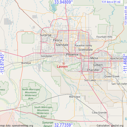
Laveen GPS coordinates[2]
33° 21' 46.152" North, 112° 10' 9.552" West
| Map corner | latitude | longitude |
|---|---|---|
| Upper-left | 33.94809°, | -112.87245° |
| Center: | 33.36282°, | -112.16932° |
| Lower-right: | 32.77359°, | -111.4662° |
| Map W x H: | 130.6×130.6 km | = 81.2×81.2mi |
| max Lat: | 71.29058° ⇑83.7% North |
| Laveen: | 33.36282° |
| min Lat: | ⇓16.3% South 19.06759° |
| min Long | Laveen | max Long |
| -171.73463° | -112.16932° | -66.98998° |
| W 12.2%⇐ | ⇒87.8% E |
Elevation
Elevation of Laveen is 315 m = 1033 ft, and this is 20.2 m = 66 ft above average elevation for this country.
| Max E: |
3189 m = 10463 ft | 24.7% |
| Laveen | 315 m 1033 ft | |
| Avg. | 294.8 m = 967 ft | |
Min E: |
-60 m = -197 ft | 75.3% |
See also: United States elevation on elevation.city.
Geographical zone
Laveen is located in North temperate zone (between Tropic of Cancer and the Arctic Circle). Distance of this Northern Tropic circle is 1103.7 km =685.8 mi to South.| Distance of | km | miles | from Laveen |
|---|---|---|---|
| North Pole | 6297.5 | 3913.1 | to North |
| Arctic Circle | 3691.6 | 2293.9 | to North |
| Tropic Cancer | 1103.7 | 685.8 | to South |
| Equator | 3709.6 | 2305 | to South |


Nearby cities:
15 places around Laveen: (largest is in red/bold)
• Ahwatukee Foothills
17.4 km =10.8 mi,  97°
97°
• Alhambra
15.4 km =9.6 mi,  12°
12°
• Avondale
18.6 km =11.6 mi,  295°
295°
• Central City
13.4 km =8.3 mi,  50°
50°
• Encanto
15.5 km =9.6 mi,  33°
33°
• Gila Crossing
9.6 km =6 mi,  178°
178°
• Glendale
19.6 km =12.2 mi,  355°
355°
• Goodyear
19.3 km =12 mi,  294°
294°
• Guadalupe
19.2 km =11.9 mi,  87°
87°
• Komatke
7.7 km =4.8 mi, 184°
• Litchfield Park
22.7 km =14.1 mi,  309°
309°
• Maryvale
15.5 km =9.6 mi, 357°
• Phoenix
13 km =8.1 mi,  42°
42°
• Tempe Junction
21.7 km =13.5 mi,  74°
74°
• Tolleson
12.8 km =8 mi,  319°
319°
Sources, notices
• [Note1] Compared only with cities in United States existing in our database
• [Src1] Map data: © OpenStreetMap contributors (CC-BY-SA)
• [Src2] Other city data from geonames.org with taken over terms of usage.
• [Src3] Geographical zone / Annual Mean Temperature by Robert A. Rohde @ Wikipedia
