Glendale geodata
Glendale (Arizona) is a populated place; located in United States in America/Phoenix (GMT-7) time zone. With population of 240,126 people, there are 98 cities with bigger population in this country. Compared to other cities in United States, 82.9% of cities are located further ↑North; 87.9% of cities are located further →East and 79.7% of cities have lower elevation than Glendale. Note1


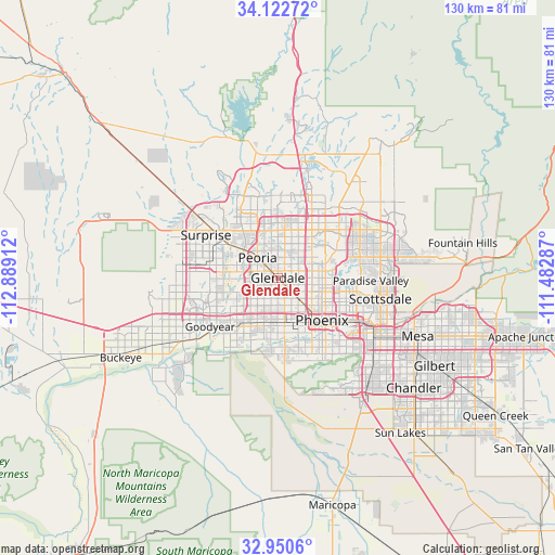
Glendale GPS coordinates[2]
33° 32' 19.14" North, 112° 11' 9.564" West
| Map corner | latitude | longitude |
|---|---|---|
| Upper-left | 34.12272°, | -112.88912° |
| Center: | 33.53865°, | -112.18599° |
| Lower-right: | 32.9506°, | -111.48287° |
| Map W x H: | 130.3×130.3 km | = 81×81mi |
| max Lat: | 71.29058° ⇑82.9% North |
| Glendale: | 33.53865° |
| min Lat: | ⇓17.1% South 19.06759° |
| min Long | Glendale | max Long |
| -171.73463° | -112.18599° | -66.98998° |
| W 12.1%⇐ | ⇒87.9% E |
Elevation
Elevation of Glendale is 350 m = 1148 ft, and this is 55.2 m = 181 ft above average elevation for this country.
| Max E: |
3189 m = 10463 ft | 20.3% |
| Glendale | 350 m 1148 ft | |
| Avg. | 294.8 m = 967 ft | |
Min E: |
-60 m = -197 ft | 79.7% |
See also: Glendale elevation on elevation.city.
Geographical zone
Glendale is located in North temperate zone (between Tropic of Cancer and the Arctic Circle). Distance of this Northern Tropic circle is 1123.2 km =697.9 mi to South.| Distance of | km | miles | from Glendale |
|---|---|---|---|
| North Pole | 6277.9 | 3900.9 | to North |
| Arctic Circle | 3672 | 2281.7 | to North |
| Tropic Cancer | 1123.2 | 697.9 | to South |
| Equator | 3729.1 | 2317.2 | to South |


Nearby cities:
15 places around Glendale: (largest is in red/bold)
• Alhambra
6.6 km =4.1 mi,  133°
133°
• Avondale
19 km =11.8 mi,  232°
232°
• Central City
16.2 km =10.1 mi, 132°
• Deer Valley
16.8 km =10.4 mi,  16°
16°
• El Mirage
15.3 km =9.5 mi,  302°
302°
• Encanto
12 km =7.5 mi,  123°
123°
• Laveen
19.6 km =12.2 mi,  175°
175°
• Litchfield Park
16.7 km =10.4 mi,  252°
252°
• Maryvale
4.1 km =2.5 mi,  169°
169°
• Peoria
6.7 km =4.2 mi,  314°
314°
• Phoenix
14.4 km =8.9 mi, 134°
• Sun City
10.3 km =6.4 mi, 309°
• Surprise
17 km =10.6 mi, 306°
• Tolleson
12 km =7.5 mi,  214°
214°
• Youngtown
12.5 km =7.8 mi, 299°
Sources, notices
• [Note1] Compared only with cities in United States existing in our database
• [Src1] Map data: © OpenStreetMap contributors (CC-BY-SA)
• [Src2] Other city data from geonames.org with taken over terms of usage.
• [Src3] Geographical zone / Annual Mean Temperature by Robert A. Rohde @ Wikipedia
