Phoenix geodata
Phoenix (Arizona) is a seat of a first-order administrative division; located in United States in America/Phoenix (GMT-7) time zone. With population of 1,563,025 people, there are 7 cities with bigger population in this country. Compared to other cities in United States, 83.4% of cities are located further ↑North; 87.6% of cities are located further →East and 81.1% of cities have lower elevation than Phoenix. Note1


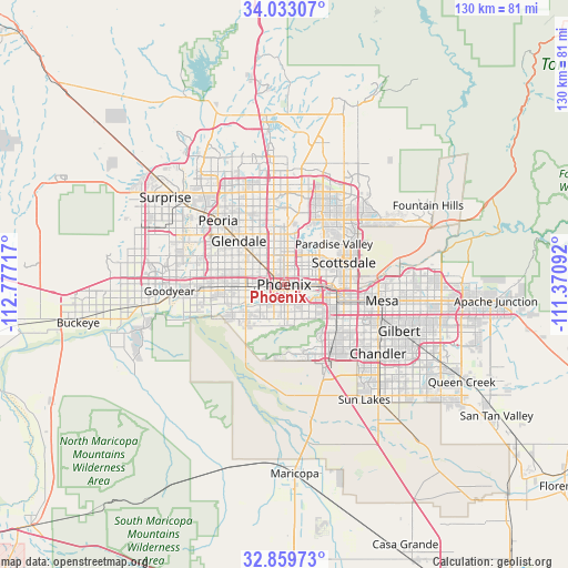
Phoenix GPS coordinates[2]
33° 26' 54.168" North, 112° 4' 26.544" West
| Map corner | latitude | longitude |
|---|---|---|
| Upper-left | 34.03307°, | -112.77717° |
| Center: | 33.44838°, | -112.07404° |
| Lower-right: | 32.85973°, | -111.37092° |
| Map W x H: | 130.5×130.5 km | = 81.1×81.1mi |
| max Lat: | 71.29058° ⇑83.4% North |
| Phoenix: | 33.44838° |
| min Lat: | ⇓16.6% South 19.06759° |
| min Long | Phoenix | max Long |
| -171.73463° | -112.07404° | -66.98998° |
| W 12.4%⇐ | ⇒87.6% E |
Elevation
Elevation of Phoenix is 366 m = 1201 ft, and this is 71.2 m = 234 ft above average elevation for this country.
| Max E: |
3189 m = 10463 ft | 18.9% |
| Phoenix | 366 m 1201 ft | |
| Avg. | 294.8 m = 967 ft | |
Min E: |
-60 m = -197 ft | 81.1% |
See also: Phoenix elevation on elevation.city.
Geographical zone
Phoenix is located in North temperate zone (between Tropic of Cancer and the Arctic Circle). Distance of this Northern Tropic circle is 1113.2 km =691.7 mi to South.| Distance of | km | miles | from Phoenix |
|---|---|---|---|
| North Pole | 6288 | 3907.2 | to North |
| Arctic Circle | 3682.1 | 2288 | to North |
| Tropic Cancer | 1113.2 | 691.7 | to South |
| Equator | 3719.1 | 2310.9 | to South |


Nearby cities:
15 places around Phoenix: (largest is in red/bold)
• Ahwatukee Foothills
14.5 km =9 mi,  144°
144°
• Alhambra
7.9 km =4.9 mi,  314°
314°
• Central City
1.8 km =1.1 mi,  122°
122°
• Encanto
3.5 km =2.2 mi,  353°
353°
• Gila Crossing
20.9 km =13 mi,  204°
204°
• Glendale
14.4 km =8.9 mi, 314°
• Guadalupe
13.4 km =8.3 mi,  129°
129°
• Komatke
19.6 km =12.2 mi,  208°
208°
• Laveen
13 km =8.1 mi,  222°
222°
• Maryvale
11.3 km =7 mi,  301°
301°
• Paradise Valley
15.3 km =9.5 mi,  52°
52°
• Scottsdale
17.6 km =10.9 mi,  67°
67°
• Tempe
15.7 km =9.8 mi,  103°
103°
• Tempe Junction
12.7 km =7.9 mi,  107°
107°
• Tolleson
17.2 km =10.7 mi,  270°
270°
Sources, notices
• [Note1] Compared only with cities in United States existing in our database
• [Src1] Map data: © OpenStreetMap contributors (CC-BY-SA)
• [Src2] Other city data from geonames.org with taken over terms of usage.
• [Src3] Geographical zone / Annual Mean Temperature by Robert A. Rohde @ Wikipedia
