Maryvale geodata
Maryvale (Arizona) is a populated place; located in United States in America/Phoenix (GMT-7) time zone. With population of 208,189 people, there are 117 cities with bigger population in this country. Compared to other cities in United States, 83.1% of cities are located further ↑North; 87.8% of cities are located further →East and 78.6% of cities have lower elevation than Maryvale. Note1


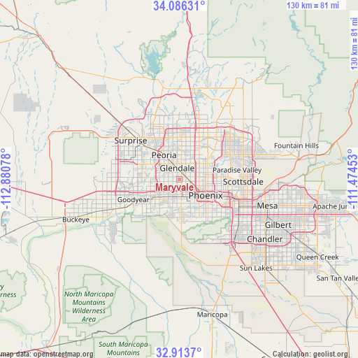
Maryvale GPS coordinates[2]
33° 30' 7.164" North, 112° 10' 39.54" West
| Map corner | latitude | longitude |
|---|---|---|
| Upper-left | 34.08631°, | -112.88078° |
| Center: | 33.50199°, | -112.17765° |
| Lower-right: | 32.9137°, | -111.47453° |
| Map W x H: | 130.4×130.4 km | = 81×81mi |
| max Lat: | 71.29058° ⇑83.1% North |
| Maryvale: | 33.50199° |
| min Lat: | ⇓16.9% South 19.06759° |
| min Long | Maryvale | max Long |
| -171.73463° | -112.17765° | -66.98998° |
| W 12.2%⇐ | ⇒87.8% E |
Elevation
Elevation of Maryvale is 341 m = 1119 ft, and this is 46.2 m = 152 ft above average elevation for this country.
| Max E: |
3189 m = 10463 ft | 21.4% |
| Maryvale | 341 m 1119 ft | |
| Avg. | 294.8 m = 967 ft | |
Min E: |
-60 m = -197 ft | 78.6% |
See also: Maryvale elevation on elevation.city.
Geographical zone
Maryvale is located in North temperate zone (between Tropic of Cancer and the Arctic Circle). Distance of this Northern Tropic circle is 1119.2 km =695.4 mi to South.| Distance of | km | miles | from Maryvale |
|---|---|---|---|
| North Pole | 6282 | 3903.5 | to North |
| Arctic Circle | 3676.1 | 2284.2 | to North |
| Tropic Cancer | 1119.2 | 695.4 | to South |
| Equator | 3725.1 | 2314.7 | to South |


Nearby cities:
15 places around Maryvale: (largest is in red/bold)
• Alhambra
4 km =2.5 mi,  95°
95°
• Avondale
17.6 km =10.9 mi,  245°
245°
• Central City
13.1 km =8.1 mi,  121°
121°
• El Mirage
18.4 km =11.4 mi,  312°
312°
• Encanto
9.6 km =6 mi,  105°
105°
• Glendale
4.1 km =2.5 mi,  349°
349°
• Goodyear
18.3 km =11.4 mi, 246°
• Laveen
15.5 km =9.6 mi,  177°
177°
• Litchfield Park
16.7 km =10.4 mi,  266°
266°
• Peoria
10.3 km =6.4 mi,  327°
327°
• Phoenix
11.3 km =7 mi, 121°
• Sun City
13.7 km =8.5 mi,  320°
320°
• Surprise
20.3 km =12.6 mi, 314°
• Tolleson
9.5 km =5.9 mi,  232°
232°
• Youngtown
15.5 km =9.6 mi, 311°
Sources, notices
• [Note1] Compared only with cities in United States existing in our database
• [Src1] Map data: © OpenStreetMap contributors (CC-BY-SA)
• [Src2] Other city data from geonames.org with taken over terms of usage.
• [Src3] Geographical zone / Annual Mean Temperature by Robert A. Rohde @ Wikipedia
