Prescott geodata
Prescott (Arizona) is a seat of a second-order administrative division; located in United States in America/Phoenix (GMT-7) time zone. With population of 41,899 people, there are 1145 cities with bigger population in this country. Compared to other cities in United States, 77.5% of cities are located further ↑North; 88.1% of cities are located further →East and 97.6% of cities have lower elevation than Prescott. Note1


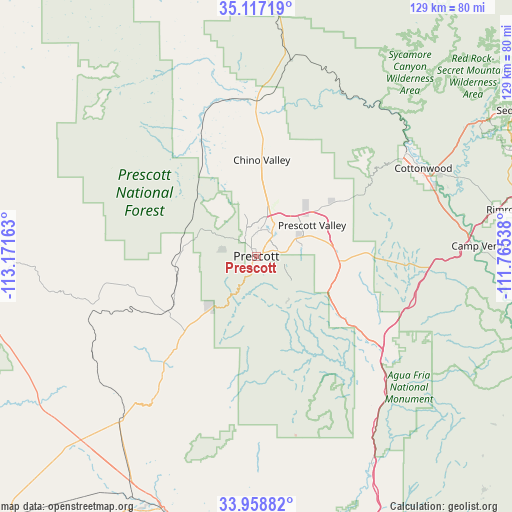
Prescott GPS coordinates[2]
34° 32' 24.072" North, 112° 28' 6.6" West
| Map corner | latitude | longitude |
|---|---|---|
| Upper-left | 35.11719°, | -113.17163° |
| Center: | 34.54002°, | -112.4685° |
| Lower-right: | 33.95882°, | -111.76538° |
| Map W x H: | 128.8×128.8 km | = 80×80mi |
| max Lat: | 71.29058° ⇑77.5% North |
| Prescott: | 34.54002° |
| min Lat: | ⇓22.5% South 19.06759° |
| min Long | Prescott | max Long |
| -171.73463° | -112.4685° | -66.98998° |
| W 11.9%⇐ | ⇒88.1% E |
Elevation
Elevation of Prescott is 1638 m = 5374 ft, and this is 1343.2 m = 4407 ft above average elevation for this country.
| Max E: |
3189 m = 10463 ft | 2.4% |
| Prescott | 1638 m 5374 ft | |
| Avg. | 294.8 m = 967 ft | |
Min E: |
-60 m = -197 ft | 97.6% |
See also: Prescott elevation on elevation.city.
Geographical zone
Prescott is located in North temperate zone (between Tropic of Cancer and the Arctic Circle). Distance of this Northern Tropic circle is 1234.6 km =767.1 mi to South.| Distance of | km | miles | from Prescott |
|---|---|---|---|
| North Pole | 6166.6 | 3831.7 | to North |
| Arctic Circle | 3560.7 | 2212.5 | to North |
| Tropic Cancer | 1234.6 | 767.1 | to South |
| Equator | 3840.5 | 2386.4 | to South |


Nearby cities:
15 places around Prescott: (largest is in red/bold)
• Chino Valley
24.2 km =15 mi,  3°
3°
• Clarkdale
45.5 km =28.3 mi,  55°
55°
• Congress
54.7 km =34 mi,  219°
219°
• Cordes Lakes
42.3 km =26.3 mi,  127°
127°
• Cornville
53.8 km =33.4 mi,  68°
68°
• Cottonwood
47.4 km =29.5 mi, 62°
• Dewey-Humboldt
20.8 km =12.9 mi,  93°
93°
• Mayer
26.5 km =16.5 mi, 126°
• Paulden
38.4 km =23.9 mi, 0°
• Prescott Valley
16 km =9.9 mi, 60°
• Spring Valley
35.7 km =22.2 mi, 127°
• Verde Village
45.9 km =28.5 mi, 65°
• Wilhoit
16.7 km =10.4 mi, 220°
• Williamson
17.9 km =11.1 mi,  338°
338°
• Yarnell
43.7 km =27.2 mi, 215°
Sources, notices
• [Note1] Compared only with cities in United States existing in our database
• [Src1] Map data: © OpenStreetMap contributors (CC-BY-SA)
• [Src2] Other city data from geonames.org with taken over terms of usage.
• [Src3] Geographical zone / Annual Mean Temperature by Robert A. Rohde @ Wikipedia
