Sun City geodata
Sun City (Arizona) is a populated place; located in United States in America/Phoenix (GMT-7) time zone. With population of 37,499 people, there are 1296 cities with bigger population in this country. Compared to other cities in United States, 82.7% of cities are located further ↑North; 87.9% of cities are located further →East and 79.3% of cities have lower elevation than Sun City. Note1


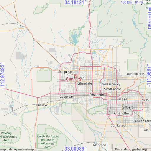
Sun City GPS coordinates[2]
33° 35' 51.144" North, 112° 16' 18.552" West
| Map corner | latitude | longitude |
|---|---|---|
| Upper-left | 34.18121°, | -112.97495° |
| Center: | 33.59754°, | -112.27182° |
| Lower-right: | 33.00989°, | -111.5687° |
| Map W x H: | 130.2×130.2 km | = 80.9×80.9mi |
| max Lat: | 71.29058° ⇑82.7% North |
| Sun City: | 33.59754° |
| min Lat: | ⇓17.3% South 19.06759° |
| min Long | Sun City | max Long |
| -171.73463° | -112.27182° | -66.98998° |
| W 12.1%⇐ | ⇒87.9% E |
Elevation
Elevation of Sun City is 347 m = 1138 ft, and this is 52.2 m = 171 ft above average elevation for this country.
| Max E: |
3189 m = 10463 ft | 20.7% |
| Sun City | 347 m 1138 ft | |
| Avg. | 294.8 m = 967 ft | |
Min E: |
-60 m = -197 ft | 79.3% |
See also: United States elevation on elevation.city.
Geographical zone
Sun City is located in North temperate zone (between Tropic of Cancer and the Arctic Circle). Distance of this Northern Tropic circle is 1129.8 km =702 mi to South.| Distance of | km | miles | from Sun City |
|---|---|---|---|
| North Pole | 6271.4 | 3896.9 | to North |
| Arctic Circle | 3665.5 | 2277.6 | to North |
| Tropic Cancer | 1129.8 | 702 | to South |
| Equator | 3735.7 | 2321.3 | to South |


Nearby cities:
15 places around Sun City: (largest is in red/bold)
• Alhambra
16.8 km =10.4 mi,  130°
130°
• Avondale
19.4 km =12.1 mi,  201°
201°
• Citrus Park
16.9 km =10.5 mi,  251°
251°
• Deer Valley
15.9 km =9.9 mi,  52°
52°
• El Mirage
5.2 km =3.2 mi,  289°
289°
• Encanto
22.2 km =13.8 mi, 126°
• Glendale
10.3 km =6.4 mi, 129°
• Goodyear
19.7 km =12.2 mi, 203°
• Litchfield Park
14.1 km =8.8 mi,  214°
214°
• Maryvale
13.7 km =8.5 mi,  140°
140°
• Peoria
3.7 km =2.3 mi,  120°
120°
• Sun City West
9.6 km =6 mi,  318°
318°
• Surprise
6.8 km =4.2 mi,  302°
302°
• Tolleson
16.4 km =10.2 mi,  175°
175°
• Youngtown
2.9 km =1.8 mi,  262°
262°
Sources, notices
• [Note1] Compared only with cities in United States existing in our database
• [Src1] Map data: © OpenStreetMap contributors (CC-BY-SA)
• [Src2] Other city data from geonames.org with taken over terms of usage.
• [Src3] Geographical zone / Annual Mean Temperature by Robert A. Rohde @ Wikipedia
