Surprise geodata
Surprise (Arizona) is a populated place; located in United States in America/Phoenix (GMT-7) time zone. With population of 128,422 people, there are 242 cities with bigger population in this country. Compared to other cities in United States, 82.4% of cities are located further ↑North; 88% of cities are located further →East and 80.4% of cities have lower elevation than Surprise. Note1


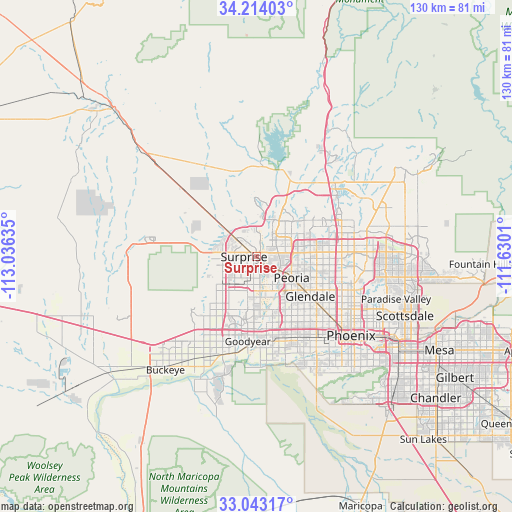
Surprise GPS coordinates[2]
33° 37' 50.124" North, 112° 19' 59.592" West
| Map corner | latitude | longitude |
|---|---|---|
| Upper-left | 34.21403°, | -113.03635° |
| Center: | 33.63059°, | -112.33322° |
| Lower-right: | 33.04317°, | -111.6301° |
| Map W x H: | 130.2×130.2 km | = 80.9×80.9mi |
| max Lat: | 71.29058° ⇑82.4% North |
| Surprise: | 33.63059° |
| min Lat: | ⇓17.6% South 19.06759° |
| min Long | Surprise | max Long |
| -171.73463° | -112.33322° | -66.98998° |
| W 12%⇐ | ⇒88% E |
Elevation
Elevation of Surprise is 357 m = 1171 ft, and this is 62.2 m = 204 ft above average elevation for this country.
| Max E: |
3189 m = 10463 ft | 19.6% |
| Surprise | 357 m 1171 ft | |
| Avg. | 294.8 m = 967 ft | |
Min E: |
-60 m = -197 ft | 80.4% |
See also: Surprise elevation on elevation.city.
Geographical zone
Surprise is located in North temperate zone (between Tropic of Cancer and the Arctic Circle). Distance of this Northern Tropic circle is 1133.5 km =704.3 mi to South.| Distance of | km | miles | from Surprise |
|---|---|---|---|
| North Pole | 6267.7 | 3894.6 | to North |
| Arctic Circle | 3661.8 | 2275.3 | to North |
| Tropic Cancer | 1133.5 | 704.3 | to South |
| Equator | 3739.4 | 2323.6 | to South |


Nearby cities:
15 places around Surprise: (largest is in red/bold)
• Alhambra
23.6 km =14.7 mi,  128°
128°
• Avondale
21.7 km =13.5 mi,  184°
184°
• Citrus Park
13.7 km =8.5 mi,  228°
228°
• Deer Valley
19.3 km =12 mi,  72°
72°
• El Mirage
2.1 km =1.3 mi,  157°
157°
• Glendale
17 km =10.6 mi, 126°
• Goodyear
21.8 km =13.5 mi,  186°
186°
• Litchfield Park
15.4 km =9.6 mi, 188°
• Maryvale
20.3 km =12.6 mi, 134°
• Peoria
10.5 km =6.5 mi,  122°
122°
• Sun City
6.8 km =4.2 mi, 122°
• Sun City West
3.6 km =2.2 mi,  347°
347°
• Tolleson
21.2 km =13.2 mi, 161°
• Wittmann
24.3 km =15.1 mi,  311°
311°
• Youngtown
4.9 km =3 mi,  145°
145°
Sources, notices
• [Note1] Compared only with cities in United States existing in our database
• [Src1] Map data: © OpenStreetMap contributors (CC-BY-SA)
• [Src2] Other city data from geonames.org with taken over terms of usage.
• [Src3] Geographical zone / Annual Mean Temperature by Robert A. Rohde @ Wikipedia
