Yah-ta-hey geodata
Yah-ta-hey (New Mexico) is a populated place; located in United States in America/Denver (GMT-6) time zone. With population of 590 people, there are 19817 cities with bigger population in this country. Compared to other cities in United States, 72.1% of cities are located further ↑North; 85.3% of cities are located further →East and 99.1% of cities have lower elevation than Yah-ta-hey. Note1


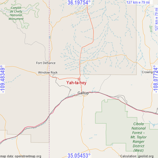
Yah-ta-hey GPS coordinates[2]
35° 37' 41.088" North, 108° 46' 49.296" West
| Map corner | latitude | longitude |
|---|---|---|
| Upper-left | 36.19754°, | -109.48349° |
| Center: | 35.62808°, | -108.78036° |
| Lower-right: | 35.05453°, | -108.07724° |
| Map W x H: | 127.1×127.1 km | = 79×79mi |
| max Lat: | 71.29058° ⇑72.1% North |
| Yah-ta-hey: | 35.62808° |
| min Lat: | ⇓27.9% South 19.06759° |
| min Long | Yah-ta-hey | max Long |
| -171.73463° | -108.78036° | -66.98998° |
| W 14.7%⇐ | ⇒85.3% E |
Elevation
Elevation of Yah-ta-hey is 2006 m = 6581 ft, and this is 1711.2 m = 5614 ft above average elevation for this country.
| Max E: |
3189 m = 10463 ft | 0.90000000000001% |
| Yah-ta-hey | 2006 m 6581 ft | |
| Avg. | 294.8 m = 967 ft | |
Min E: |
-60 m = -197 ft | 99.1% |
See also: United States elevation on elevation.city.
Geographical zone
Yah-ta-hey is located in North temperate zone (between Tropic of Cancer and the Arctic Circle). Distance of this Northern Tropic circle is 1355.6 km =842.3 mi to South.| Distance of | km | miles | from Yah-ta-hey |
|---|---|---|---|
| North Pole | 6045.6 | 3756.6 | to North |
| Arctic Circle | 3439.7 | 2137.3 | to North |
| Tropic Cancer | 1355.6 | 842.3 | to South |
| Equator | 3961.5 | 2461.6 | to South |


Nearby cities:
15 places around Yah-ta-hey: (largest is in red/bold)
• Black Rock
60 km =37.3 mi,  180°
180°
• Church Rock
19.4 km =12.1 mi,  122°
122°
• Crownpoint
57.1 km =35.5 mi,  84°
84°
• Fort Defiance
29.7 km =18.5 mi,  295°
295°
• Gallup
11.6 km =7.2 mi,  162°
162°
• Houck
54.5 km =33.9 mi,  225°
225°
• Navajo
37.9 km =23.5 mi,  322°
322°
• Rock Springs
4.9 km =3 mi,  244°
244°
• Saint Michaels
28.6 km =17.8 mi,  273°
273°
• Sawmill
46.3 km =28.8 mi,  311°
311°
• Thoreau
56.3 km =35 mi, 116°
• Tohatchi
25.7 km =16 mi,  3°
3°
• Twin Lakes
9 km =5.6 mi, 3°
• Window Rock
25.3 km =15.7 mi,  283°
283°
• Zuni Pueblo
62.1 km =38.6 mi,  185°
185°
Sources, notices
• [Note1] Compared only with cities in United States existing in our database
• [Src1] Map data: © OpenStreetMap contributors (CC-BY-SA)
• [Src2] Other city data from geonames.org with taken over terms of usage.
• [Src3] Geographical zone / Annual Mean Temperature by Robert A. Rohde @ Wikipedia
