Twin Lakes geodata
Twin Lakes (New Mexico) is a populated place; located in United States in America/Denver (GMT-6) time zone. With population of 1,052 people, there are 15940 cities with bigger population in this country. Compared to other cities in United States, 71.7% of cities are located further ↑North; 85.3% of cities are located further →East and 98.9% of cities have lower elevation than Twin Lakes. Note1


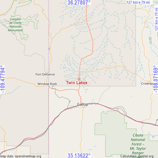
Twin Lakes GPS coordinates[2]
35° 42' 33.084" North, 108° 46' 29.316" West
| Map corner | latitude | longitude |
|---|---|---|
| Upper-left | 36.27807°, | -109.47794° |
| Center: | 35.70919°, | -108.77481° |
| Lower-right: | 35.13622°, | -108.07169° |
| Map W x H: | 127×127 km | = 78.9×78.9mi |
| max Lat: | 71.29058° ⇑71.7% North |
| Twin Lakes: | 35.70919° |
| min Lat: | ⇓28.3% South 19.06759° |
| min Long | Twin Lakes | max Long |
| -171.73463° | -108.77481° | -66.98998° |
| W 14.7%⇐ | ⇒85.3% E |
Elevation
Elevation of Twin Lakes is 1941 m = 6368 ft, and this is 1646.2 m = 5401 ft above average elevation for this country.
| Max E: |
3189 m = 10463 ft | 1.1% |
| Twin Lakes | 1941 m 6368 ft | |
| Avg. | 294.8 m = 967 ft | |
Min E: |
-60 m = -197 ft | 98.9% |
See also: United States elevation on elevation.city.
Geographical zone
Twin Lakes is located in North temperate zone (between Tropic of Cancer and the Arctic Circle). Distance of this Northern Tropic circle is 1364.6 km =847.9 mi to South.| Distance of | km | miles | from Twin Lakes |
|---|---|---|---|
| North Pole | 6036.6 | 3751 | to North |
| Arctic Circle | 3430.7 | 2131.7 | to North |
| Tropic Cancer | 1364.6 | 847.9 | to South |
| Equator | 3970.5 | 2467.2 | to South |


Nearby cities:
15 places around Twin Lakes: (largest is in red/bold)
• Black Rock
69 km =42.9 mi,  181°
181°
• Church Rock
25.1 km =15.6 mi,  140°
140°
• Crownpoint
56.4 km =35 mi,  93°
93°
• Fort Defiance
27.5 km =17.1 mi,  278°
278°
• Gallup
20.3 km =12.6 mi,  171°
171°
• Ganado
69.3 km =43.1 mi,  270°
270°
• Houck
61.4 km =38.2 mi,  219°
219°
• Navajo
31.6 km =19.6 mi,  312°
312°
• Rock Springs
12.1 km =7.5 mi,  203°
203°
• Saint Michaels
29.9 km =18.6 mi,  256°
256°
• Sawmill
41.3 km =25.7 mi,  301°
301°
• Thoreau
60.4 km =37.5 mi,  124°
124°
• Tohatchi
16.7 km =10.4 mi,  4°
4°
• Window Rock
25.3 km =15.7 mi, 262°
• Yah-ta-hey
9 km =5.6 mi, 183°
Sources, notices
• [Note1] Compared only with cities in United States existing in our database
• [Src1] Map data: © OpenStreetMap contributors (CC-BY-SA)
• [Src2] Other city data from geonames.org with taken over terms of usage.
• [Src3] Geographical zone / Annual Mean Temperature by Robert A. Rohde @ Wikipedia
