Leupp geodata
Leupp (Arizona) is a populated place; located in United States in America/Denver (GMT-6) time zone. With population of 951 people, there are 16634 cities with bigger population in this country. Compared to other cities in United States, 73.7% of cities are located further ↑North; 86.3% of cities are located further →East and 96.3% of cities have lower elevation than Leupp. Note1


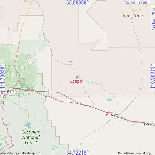
Leupp GPS coordinates[2]
35° 17' 53.052" North, 111° 0' 22.5" West
| Map corner | latitude | longitude |
|---|---|---|
| Upper-left | 35.86989°, | -111.70938° |
| Center: | 35.29807°, | -111.00625° |
| Lower-right: | 34.72218°, | -110.30313° |
| Map W x H: | 127.6×127.6 km | = 79.3×79.3mi |
| max Lat: | 71.29058° ⇑73.7% North |
| Leupp: | 35.29807° |
| min Lat: | ⇓26.3% South 19.06759° |
| min Long | Leupp | max Long |
| -171.73463° | -111.00625° | -66.98998° |
| W 13.7%⇐ | ⇒86.3% E |
Elevation
Elevation of Leupp is 1454 m = 4770 ft, and this is 1159.2 m = 3803 ft above average elevation for this country.
| Max E: |
3189 m = 10463 ft | 3.7% |
| Leupp | 1454 m 4770 ft | |
| Avg. | 294.8 m = 967 ft | |
Min E: |
-60 m = -197 ft | 96.3% |
See also: United States elevation on elevation.city.
Geographical zone
Leupp is located in North temperate zone (between Tropic of Cancer and the Arctic Circle). Distance of this Northern Tropic circle is 1318.9 km =819.5 mi to South.| Distance of | km | miles | from Leupp |
|---|---|---|---|
| North Pole | 6082.3 | 3779.4 | to North |
| Arctic Circle | 3476.4 | 2160.1 | to North |
| Tropic Cancer | 1318.9 | 819.5 | to South |
| Equator | 3924.8 | 2438.8 | to South |


Nearby cities:
15 places around Leupp: (largest is in red/bold)
• Cameron
74 km =46 mi,  330°
330°
• Dilkon
62.9 km =39.1 mi,  81°
81°
• First Mesa
82.3 km =51.1 mi,  43°
43°
• Flagstaff
59.6 km =37 mi,  259°
259°
• Hotevilla-Bacavi
76.2 km =47.3 mi,  23°
23°
• Joseph City
72 km =44.7 mi,  121°
121°
• Kachina Village
66.3 km =41.2 mi,  250°
250°
• Kykotsmovi Village
72.8 km =45.2 mi,  28°
28°
• LeChee
37.5 km =23.3 mi,  142°
142°
• Mountainaire
64.4 km =40 mi, 248°
• Munds Park
69.7 km =43.3 mi,  235°
235°
• Second Mesa
71.3 km =44.3 mi, 39°
• Shongopovi
71.9 km =44.7 mi, 36°
• Shungopavi
71.1 km =44.2 mi, 37°
• Winslow
41.4 km =25.7 mi, 137°
Sources, notices
• [Note1] Compared only with cities in United States existing in our database
• [Src1] Map data: © OpenStreetMap contributors (CC-BY-SA)
• [Src2] Other city data from geonames.org with taken over terms of usage.
• [Src3] Geographical zone / Annual Mean Temperature by Robert A. Rohde @ Wikipedia
