Beaumont geodata
Beaumont (California) is a populated place; located in United States in America/Los_Angeles (GMT-7) time zone. With population of 43,811 people, there are 1090 cities with bigger population in this country. Compared to other cities in United States, 80.7% of cities are located further ↑North; 89.7% of cities are located further →East and 92% of cities have lower elevation than Beaumont. Note1


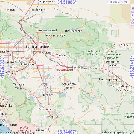
Beaumont GPS coordinates[2]
33° 55' 46.056" North, 116° 58' 38.1" West
| Map corner | latitude | longitude |
|---|---|---|
| Upper-left | 34.51086°, | -117.68038° |
| Center: | 33.92946°, | -116.97725° |
| Lower-right: | 33.34407°, | -116.27413° |
| Map W x H: | 129.7×129.7 km | = 80.6×80.6mi |
| max Lat: | 71.29058° ⇑80.7% North |
| Beaumont: | 33.92946° |
| min Lat: | ⇓19.3% South 19.06759° |
| min Long | Beaumont | max Long |
| -171.73463° | -116.97725° | -66.98998° |
| W 10.3%⇐ | ⇒89.7% E |
Elevation
Elevation of Beaumont is 797 m = 2615 ft, and this is 502.2 m = 1648 ft above average elevation for this country.
| Max E: |
3189 m = 10463 ft | 8% |
| Beaumont | 797 m 2615 ft | |
| Avg. | 294.8 m = 967 ft | |
Min E: |
-60 m = -197 ft | 92% |
See also: Beaumont elevation on elevation.city.
Geographical zone
Beaumont is located in North temperate zone (between Tropic of Cancer and the Arctic Circle). Distance of this Northern Tropic circle is 1166.7 km =725 mi to South.| Distance of | km | miles | from Beaumont |
|---|---|---|---|
| North Pole | 6234.5 | 3873.9 | to North |
| Arctic Circle | 3628.6 | 2254.7 | to North |
| Tropic Cancer | 1166.7 | 725 | to South |
| Equator | 3772.6 | 2344.2 | to South |


Nearby cities:
15 places around Beaumont: (largest is in red/bold)
• Banning
9.3 km =5.8 mi,  92°
92°
• Cabazon
17.6 km =10.9 mi, 94°
• Calimesa
11.4 km =7.1 mi,  316°
316°
• Cherry Valley
4.8 km =3 mi,  0°
0°
• East Hemet
21.4 km =13.3 mi,  170°
170°
• Green Acres
23.2 km =14.4 mi,  203°
203°
• Hemet
20.2 km =12.6 mi,  178°
178°
• Lakeview
16.5 km =10.3 mi,  232°
232°
• Mentone
21.3 km =13.2 mi, 317°
• Moreno Valley
23.4 km =14.5 mi,  272°
272°
• Nuevo
21.1 km =13.1 mi, 227°
• Oak Glen
13.6 km =8.5 mi,  11°
11°
• San Jacinto
16.3 km =10.1 mi, 173°
• Valle Vista
21.6 km =13.4 mi,  159°
159°
• Yucaipa
13.1 km =8.1 mi,  332°
332°
Sources, notices
• [Note1] Compared only with cities in United States existing in our database
• [Src1] Map data: © OpenStreetMap contributors (CC-BY-SA)
• [Src2] Other city data from geonames.org with taken over terms of usage.
• [Src3] Geographical zone / Annual Mean Temperature by Robert A. Rohde @ Wikipedia
