Yucaipa geodata
Yucaipa (California) is a populated place; located in United States in America/Los_Angeles (GMT-7) time zone. With population of 53,328 people, there are 875 cities with bigger population in this country. Compared to other cities in United States, 80% of cities are located further ↑North; 89.8% of cities are located further →East and 92% of cities have lower elevation than Yucaipa. Note1


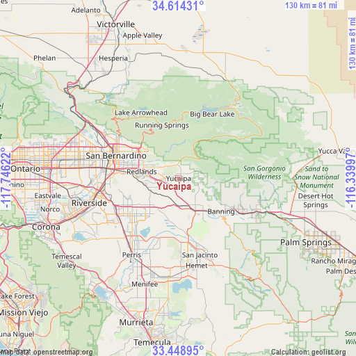
Yucaipa GPS coordinates[2]
34° 2' 1.068" North, 117° 2' 35.124" West
| Map corner | latitude | longitude |
|---|---|---|
| Upper-left | 34.61431°, | -117.74622° |
| Center: | 34.03363°, | -117.04309° |
| Lower-right: | 33.44895°, | -116.33997° |
| Map W x H: | 129.6×129.6 km | = 80.5×80.5mi |
| max Lat: | 71.29058° ⇑80% North |
| Yucaipa: | 34.03363° |
| min Lat: | ⇓20% South 19.06759° |
| min Long | Yucaipa | max Long |
| -171.73463° | -117.04309° | -66.98998° |
| W 10.2%⇐ | ⇒89.8% E |
Elevation
Elevation of Yucaipa is 799 m = 2621 ft, and this is 504.2 m = 1654 ft above average elevation for this country.
| Max E: |
3189 m = 10463 ft | 8% |
| Yucaipa | 799 m 2621 ft | |
| Avg. | 294.8 m = 967 ft | |
Min E: |
-60 m = -197 ft | 92% |
See also: Yucaipa elevation on elevation.city.
Geographical zone
Yucaipa is located in North temperate zone (between Tropic of Cancer and the Arctic Circle). Distance of this Northern Tropic circle is 1178.3 km =732.2 mi to South.| Distance of | km | miles | from Yucaipa |
|---|---|---|---|
| North Pole | 6222.9 | 3866.7 | to North |
| Arctic Circle | 3617 | 2247.5 | to North |
| Tropic Cancer | 1178.3 | 732.2 | to South |
| Equator | 3784.2 | 2351.4 | to South |


Nearby cities:
15 places around Yucaipa: (largest is in red/bold)
• Banning
19.5 km =12.1 mi,  128°
128°
• Beaumont
13.1 km =8.1 mi,  152°
152°
• Calimesa
3.7 km =2.3 mi,  207°
207°
• Cherry Valley
9.1 km =5.7 mi,  138°
138°
• Colton
25.3 km =15.7 mi,  280°
280°
• Grand Terrace
24.9 km =15.5 mi,  270°
270°
• Highland
18.5 km =11.5 mi,  304°
304°
• Lakeview
22.8 km =14.2 mi,  197°
197°
• Loma Linda
20.2 km =12.6 mi, 274°
• Mentone
9.3 km =5.8 mi, 295°
• Moreno Valley
20.3 km =12.6 mi,  238°
238°
• Oak Glen
9 km =5.6 mi,  78°
78°
• Redlands
13.1 km =8.1 mi, 280°
• Running Springs
20.3 km =12.6 mi,  342°
342°
• San Bernardino
24.2 km =15 mi,  290°
290°
Sources, notices
• [Note1] Compared only with cities in United States existing in our database
• [Src1] Map data: © OpenStreetMap contributors (CC-BY-SA)
• [Src2] Other city data from geonames.org with taken over terms of usage.
• [Src3] Geographical zone / Annual Mean Temperature by Robert A. Rohde @ Wikipedia
