Moreno Valley geodata
Moreno Valley (California) is a populated place; located in United States in America/Los_Angeles (GMT-7) time zone. With population of 204,198 people, there are 122 cities with bigger population in this country. Compared to other cities in United States, 80.7% of cities are located further ↑North; 90.1% of cities are located further →East and 87.8% of cities have lower elevation than Moreno Valley. Note1


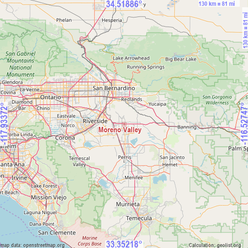
Moreno Valley GPS coordinates[2]
33° 56' 15.072" North, 117° 13' 50.124" West
| Map corner | latitude | longitude |
|---|---|---|
| Upper-left | 34.51886°, | -117.93372° |
| Center: | 33.93752°, | -117.23059° |
| Lower-right: | 33.35218°, | -116.52747° |
| Map W x H: | 129.7×129.7 km | = 80.6×80.6mi |
| max Lat: | 71.29058° ⇑80.7% North |
| Moreno Valley: | 33.93752° |
| min Lat: | ⇓19.3% South 19.06759° |
| min Long | Moreno Valley | max Long |
| -171.73463° | -117.23059° | -66.98998° |
| W 9.9%⇐ | ⇒90.1% E |
Elevation
Elevation of Moreno Valley is 499 m = 1637 ft, and this is 204.2 m = 670 ft above average elevation for this country.
| Max E: |
3189 m = 10463 ft | 12.2% |
| Moreno Valley | 499 m 1637 ft | |
| Avg. | 294.8 m = 967 ft | |
Min E: |
-60 m = -197 ft | 87.8% |
See also: Moreno Valley elevation on elevation.city.
Geographical zone
Moreno Valley is located in North temperate zone (between Tropic of Cancer and the Arctic Circle). Distance of this Northern Tropic circle is 1167.6 km =725.5 mi to South.| Distance of | km | miles | from Moreno Valley |
|---|---|---|---|
| North Pole | 6233.6 | 3873.4 | to North |
| Arctic Circle | 3627.7 | 2254.1 | to North |
| Tropic Cancer | 1167.6 | 725.5 | to South |
| Equator | 3773.5 | 2344.7 | to South |


Nearby cities:
15 places around Moreno Valley: (largest is in red/bold)
• Calimesa
17.2 km =10.7 mi,  64°
64°
• Colton
17 km =10.6 mi,  333°
333°
• Grand Terrace
13.2 km =8.2 mi,  324°
324°
• Highgrove
12.9 km =8 mi,  312°
312°
• Lakeview
15.1 km =9.4 mi,  136°
136°
• Loma Linda
12.6 km =7.8 mi,  347°
347°
• March Air Force Base
5.9 km =3.7 mi,  210°
210°
• Mead Valley
13.1 km =8.1 mi, 207°
• Mentone
17.2 km =10.7 mi,  31°
31°
• Nuevo
17 km =10.6 mi,  152°
152°
• Perris
17.2 km =10.7 mi,  179°
179°
• Redlands
13.9 km =8.6 mi,  18°
18°
• Riverside
15.4 km =9.6 mi,  276°
276°
• Rubidoux
17.4 km =10.8 mi,  291°
291°
• Woodcrest
13.2 km =8.2 mi,  242°
242°
Sources, notices
• [Note1] Compared only with cities in United States existing in our database
• [Src1] Map data: © OpenStreetMap contributors (CC-BY-SA)
• [Src2] Other city data from geonames.org with taken over terms of usage.
• [Src3] Geographical zone / Annual Mean Temperature by Robert A. Rohde @ Wikipedia
