Calimesa geodata
Calimesa (California) is a populated place; located in United States in America/Los_Angeles (GMT-7) time zone. With population of 8,542 people, there are 4996 cities with bigger population in this country. Compared to other cities in United States, 80.2% of cities are located further ↑North; 89.8% of cities are located further →East and 91.3% of cities have lower elevation than Calimesa. Note1


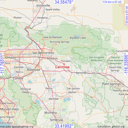
Calimesa GPS coordinates[2]
34° 0' 14.04" North, 117° 3' 43.128" West
| Map corner | latitude | longitude |
|---|---|---|
| Upper-left | 34.58478°, | -117.76511° |
| Center: | 34.0039°, | -117.06198° |
| Lower-right: | 33.41902°, | -116.35886° |
| Map W x H: | 129.6×129.6 km | = 80.5×80.5mi |
| max Lat: | 71.29058° ⇑80.2% North |
| Calimesa: | 34.0039° |
| min Lat: | ⇓19.8% South 19.06759° |
| min Long | Calimesa | max Long |
| -171.73463° | -117.06198° | -66.98998° |
| W 10.2%⇐ | ⇒89.8% E |
Elevation
Elevation of Calimesa is 732 m = 2402 ft, and this is 437.2 m = 1434 ft above average elevation for this country.
| Max E: |
3189 m = 10463 ft | 8.7% |
| Calimesa | 732 m 2402 ft | |
| Avg. | 294.8 m = 967 ft | |
Min E: |
-60 m = -197 ft | 91.3% |
See also: United States elevation on elevation.city.
Geographical zone
Calimesa is located in North temperate zone (between Tropic of Cancer and the Arctic Circle). Distance of this Northern Tropic circle is 1175 km =730.1 mi to South.| Distance of | km | miles | from Calimesa |
|---|---|---|---|
| North Pole | 6226.2 | 3868.8 | to North |
| Arctic Circle | 3620.3 | 2249.5 | to North |
| Tropic Cancer | 1175 | 730.1 | to South |
| Equator | 3780.9 | 2349.3 | to South |


Nearby cities:
15 places around Calimesa: (largest is in red/bold)
• Banning
19.2 km =11.9 mi,  116°
116°
• Beaumont
11.4 km =7.1 mi,  136°
136°
• Cherry Valley
8.6 km =5.3 mi,  114°
114°
• Grand Terrace
23.4 km =14.5 mi,  278°
278°
• Highland
19.3 km =12 mi,  315°
315°
• Lakeview
19.1 km =11.9 mi,  195°
195°
• Loma Linda
19 km =11.8 mi,  285°
285°
• March Air Force Base
22.3 km =13.9 mi,  236°
236°
• Mentone
9.9 km =6.2 mi, 317°
• Moreno Valley
17.2 km =10.7 mi, 244°
• Nuevo
23.8 km =14.8 mi, 198°
• Oak Glen
11.7 km =7.3 mi,  64°
64°
• Redlands
12.5 km =7.8 mi,  297°
297°
• Running Springs
23.1 km =14.4 mi,  349°
349°
• Yucaipa
3.7 km =2.3 mi,  27°
27°
Sources, notices
• [Note1] Compared only with cities in United States existing in our database
• [Src1] Map data: © OpenStreetMap contributors (CC-BY-SA)
• [Src2] Other city data from geonames.org with taken over terms of usage.
• [Src3] Geographical zone / Annual Mean Temperature by Robert A. Rohde @ Wikipedia
