Mentone geodata
Mentone (California) is a populated place; located in United States in America/Los_Angeles (GMT-7) time zone. With population of 8,720 people, there are 4919 cities with bigger population in this country. Compared to other cities in United States, 79.8% of cities are located further ↑North; 89.9% of cities are located further →East and 87.9% of cities have lower elevation than Mentone. Note1


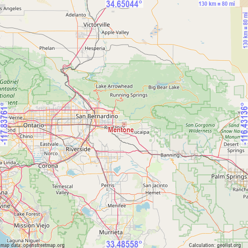
Mentone GPS coordinates[2]
34° 4' 12.036" North, 117° 8' 4.128" West
| Map corner | latitude | longitude |
|---|---|---|
| Upper-left | 34.65044°, | -117.83761° |
| Center: | 34.07001°, | -117.13448° |
| Lower-right: | 33.48558°, | -116.43136° |
| Map W x H: | 129.5×129.5 km | = 80.5×80.5mi |
| max Lat: | 71.29058° ⇑79.8% North |
| Mentone: | 34.07001° |
| min Lat: | ⇓20.2% South 19.06759° |
| min Long | Mentone | max Long |
| -171.73463° | -117.13448° | -66.98998° |
| W 10.1%⇐ | ⇒89.9% E |
Elevation
Elevation of Mentone is 504 m = 1654 ft, and this is 209.2 m = 686 ft above average elevation for this country.
| Max E: |
3189 m = 10463 ft | 12.1% |
| Mentone | 504 m 1654 ft | |
| Avg. | 294.8 m = 967 ft | |
Min E: |
-60 m = -197 ft | 87.9% |
See also: United States elevation on elevation.city.
Geographical zone
Mentone is located in North temperate zone (between Tropic of Cancer and the Arctic Circle). Distance of this Northern Tropic circle is 1182.3 km =734.6 mi to South.| Distance of | km | miles | from Mentone |
|---|---|---|---|
| North Pole | 6218.8 | 3864.2 | to North |
| Arctic Circle | 3612.9 | 2245 | to North |
| Tropic Cancer | 1182.3 | 734.6 | to South |
| Equator | 3788.2 | 2353.9 | to South |


Nearby cities:
15 places around Mentone: (largest is in red/bold)
• Beaumont
21.3 km =13.2 mi,  137°
137°
• Calimesa
9.9 km =6.2 mi, 137°
• Cherry Valley
18.1 km =11.2 mi,  126°
126°
• Colton
16.5 km =10.3 mi,  271°
271°
• Grand Terrace
17 km =10.6 mi,  256°
256°
• Highgrove
19.3 km =12 mi,  251°
251°
• Highland
9.4 km =5.8 mi,  313°
313°
• Lake Arrowhead
20.5 km =12.7 mi,  345°
345°
• Loma Linda
11.9 km =7.4 mi, 258°
• Moreno Valley
17.2 km =10.7 mi,  211°
211°
• Oak Glen
17.3 km =10.7 mi,  97°
97°
• Redlands
4.7 km =2.9 mi, 250°
• Running Springs
15.5 km =9.6 mi,  8°
8°
• San Bernardino
14.9 km =9.3 mi,  286°
286°
• Yucaipa
9.3 km =5.8 mi,  115°
115°
Sources, notices
• [Note1] Compared only with cities in United States existing in our database
• [Src1] Map data: © OpenStreetMap contributors (CC-BY-SA)
• [Src2] Other city data from geonames.org with taken over terms of usage.
• [Src3] Geographical zone / Annual Mean Temperature by Robert A. Rohde @ Wikipedia
