West Whittier-Los Nietos geodata
West Whittier-Los Nietos (California) is a populated place; located in United States in America/Los_Angeles (GMT-7) time zone. With population of 25,540 people, there are 1963 cities with bigger population in this country. Compared to other cities in United States, 80.4% of cities are located further ↑North; 91% of cities are located further →East and 79% of cities have higher elevation than West Whittier-Los Nietos. Note1
Current local time in West Whittier-Los Nietos:
10:58 AM, WednesdayDifference from your time zone: hours


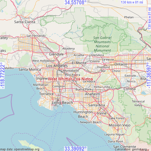
West Whittier-Los Nietos GPS coordinates[2]
33° 58' 33.6" North, 118° 4' 8.724" West
| Map corner | latitude | longitude |
|---|---|---|
| Upper-left | 34.55708°, | -118.77222° |
| Center: | 33.976°, | -118.06909° |
| Lower-right: | 33.39092°, | -117.36597° |
| Map W x H: | 129.7×129.7 km | = 80.6×80.6mi |
| max Lat: | 71.29058° ⇑80.4% North |
| West Whittier-Los Nietos: | 33.976° |
| min Lat: | ⇓19.6% South 19.06759° |
| min Long | West Whittier-L | max Long |
| -171.73463° | -118.06909° | -66.98998° |
| W 9%⇐ | ⇒91% E |
Elevation
Elevation of West Whittier-Los Nietos is 51 m = 167 ft, and this is 243.8 m = 800 ft below average elevation for this country.
| Max E: |
3189 m = 10463 ft | 79% |
| Avg. | 294.8 m = 967 ft | |
| West Whittier-Los Nietos | 51 m = 167 ft | |
Min E: |
-60 m = -197 ft | 21% |
See also: United States elevation on elevation.city.
Geographical zone
West Whittier-Los Nietos is located in North temperate zone (between Tropic of Cancer and the Arctic Circle). Distance of this Northern Tropic circle is 1171.9 km =728.2 mi to South.| Distance of | km | miles | from West Whittier-Los Nietos |
|---|---|---|---|
| North Pole | 6229.3 | 3870.7 | to North |
| Arctic Circle | 3623.4 | 2251.5 | to North |
| Tropic Cancer | 1171.9 | 728.2 | to South |
| Equator | 3777.8 | 2347.4 | to South |


Nearby cities:
15 places around West Whittier-Los Nietos: (largest is in red/bold)
• Avocado Heights
9.8 km =6.1 mi,  47°
47°
• Bell Gardens
7.7 km =4.8 mi,  261°
261°
• Commerce
8.8 km =5.5 mi,  288°
288°
• Downey
7.1 km =4.4 mi,  235°
235°
• East La Mirada
9.4 km =5.8 mi,  127°
127°
• Hacienda Heights
9.5 km =5.9 mi,  78°
78°
• La Mirada
8.4 km =5.2 mi,  141°
141°
• Montebello
5 km =3.1 mi,  318°
318°
• Norwalk
8.3 km =5.2 mi,  188°
188°
• Pico Rivera
2.7 km =1.7 mi, 287°
• Santa Fe Springs
3.5 km =2.2 mi,  205°
205°
• South El Monte
8.7 km =5.4 mi,  13°
13°
• South San Gabriel
8.5 km =5.3 mi,  343°
343°
• South Whittier
4 km =2.5 mi, 136°
• Whittier
3.4 km =2.1 mi, 83°
Sources, notices
• [Note1] Compared only with cities in United States existing in our database
• [Src1] Map data: © OpenStreetMap contributors (CC-BY-SA)
• [Src2] Other city data from geonames.org with taken over terms of usage.
• [Src3] Geographical zone / Annual Mean Temperature by Robert A. Rohde @ Wikipedia
