Downey geodata
Downey (California) is a populated place; located in United States in America/Los_Angeles (GMT-7) time zone. With population of 114,219 people, there are 280 cities with bigger population in this country. Compared to other cities in United States, 80.6% of cities are located further ↑North; 91.1% of cities are located further →East and 81.3% of cities have higher elevation than Downey. Note1


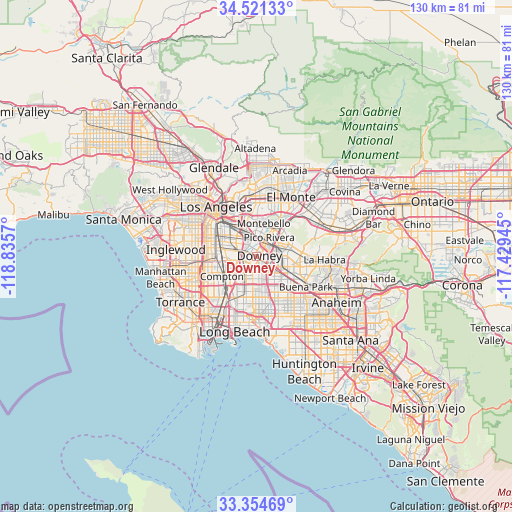
Downey GPS coordinates[2]
33° 56' 24.036" North, 118° 7' 57.252" West
| Map corner | latitude | longitude |
|---|---|---|
| Upper-left | 34.52133°, | -118.8357° |
| Center: | 33.94001°, | -118.13257° |
| Lower-right: | 33.35469°, | -117.42945° |
| Map W x H: | 129.7×129.7 km | = 80.6×80.6mi |
| max Lat: | 71.29058° ⇑80.6% North |
| Downey: | 33.94001° |
| min Lat: | ⇓19.4% South 19.06759° |
| min Long | Downey | max Long |
| -171.73463° | -118.13257° | -66.98998° |
| W 8.9%⇐ | ⇒91.1% E |
Elevation
Elevation of Downey is 41 m = 135 ft, and this is 253.8 m = 833 ft below average elevation for this country.
| Max E: |
3189 m = 10463 ft | 81.3% |
| Avg. | 294.8 m = 967 ft | |
| Downey | 41 m = 135 ft | |
Min E: |
-60 m = -197 ft | 18.7% |
See also: Downey elevation on elevation.city.
Geographical zone
Downey is located in North temperate zone (between Tropic of Cancer and the Arctic Circle). Distance of this Northern Tropic circle is 1167.9 km =725.7 mi to South.| Distance of | km | miles | from Downey |
|---|---|---|---|
| North Pole | 6233.3 | 3873.2 | to North |
| Arctic Circle | 3627.4 | 2254 | to North |
| Tropic Cancer | 1167.9 | 725.7 | to South |
| Equator | 3773.8 | 2344.9 | to South |


Nearby cities:
15 places around Downey: (largest is in red/bold)
• Bell
6.5 km =4 mi,  309°
309°
• Bell Gardens
3.3 km =2.1 mi,  328°
328°
• Bellflower
6.6 km =4.1 mi,  167°
167°
• Commerce
7.2 km =4.5 mi,  339°
339°
• Cudahy
5.4 km =3.4 mi,  295°
295°
• East Rancho Dominguez
7.4 km =4.6 mi,  231°
231°
• Lynwood
7.4 km =4.6 mi,  261°
261°
• Maywood
7.1 km =4.4 mi,  316°
316°
• Montebello
8.1 km =5 mi,  18°
18°
• Norwalk
6.3 km =3.9 mi,  131°
131°
• Paramount
6.2 km =3.9 mi,  204°
204°
• Pico Rivera
5.8 km =3.6 mi,  34°
34°
• Santa Fe Springs
4.4 km =2.7 mi,  79°
79°
• South Gate
7.5 km =4.7 mi,  282°
282°
• West Whittier-Los Nietos
7.1 km =4.4 mi,  55°
55°
Sources, notices
• [Note1] Compared only with cities in United States existing in our database
• [Src1] Map data: © OpenStreetMap contributors (CC-BY-SA)
• [Src2] Other city data from geonames.org with taken over terms of usage.
• [Src3] Geographical zone / Annual Mean Temperature by Robert A. Rohde @ Wikipedia
