Big Sur geodata
Big Sur (California) is a populated place; located in United States in America/Los_Angeles (GMT-7) time zone. With population of 1,000 people, there are 16282 cities with bigger population in this country. Compared to other cities in United States, 69.1% of cities are located further ↑North; 94.7% of cities are located further →East and 75.8% of cities have higher elevation than Big Sur. Note1


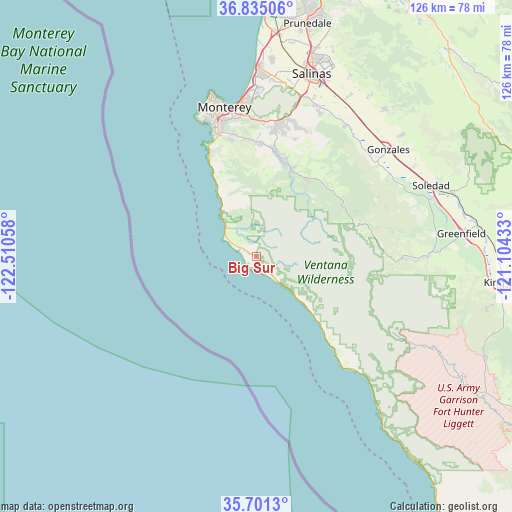
Big Sur GPS coordinates[2]
36° 16' 12.864" North, 121° 48' 26.82" West
| Map corner | latitude | longitude |
|---|---|---|
| Upper-left | 36.83506°, | -122.51058° |
| Center: | 36.27024°, | -121.80745° |
| Lower-right: | 35.7013°, | -121.10433° |
| Map W x H: | 126.1×126.1 km | = 78.4×78.4mi |
| max Lat: | 71.29058° ⇑69.1% North |
| Big Sur: | 36.27024° |
| min Lat: | ⇓30.9% South 19.06759° |
| min Long | Big Sur | max Long |
| -171.73463° | -121.80745° | -66.98998° |
| W 5.3%⇐ | ⇒94.7% E |
Elevation
Elevation of Big Sur is 67 m = 220 ft, and this is 227.8 m = 747 ft below average elevation for this country.
| Max E: |
3189 m = 10463 ft | 75.8% |
| Avg. | 294.8 m = 967 ft | |
| Big Sur | 67 m = 220 ft | |
Min E: |
-60 m = -197 ft | 24.2% |
See also: United States elevation on elevation.city.
Geographical zone
Big Sur is located in North temperate zone (between Tropic of Cancer and the Arctic Circle). Distance of this Northern Tropic circle is 1427 km =886.7 mi to South.| Distance of | km | miles | from Big Sur |
|---|---|---|---|
| North Pole | 5974.2 | 3712.2 | to North |
| Arctic Circle | 3368.3 | 2093 | to North |
| Tropic Cancer | 1427 | 886.7 | to South |
| Equator | 4032.9 | 2505.9 | to South |


Nearby cities:
15 places around Big Sur: (largest is in red/bold)
• Boronda
49.1 km =30.5 mi,  13°
13°
• Carmel Valley Village
26.5 km =16.5 mi, 8°
• Carmel-by-the-Sea
33.3 km =20.7 mi,  341°
341°
• Chualar
42.2 km =26.2 mi,  37°
37°
• Del Monte Forest
37.3 km =23.2 mi, 340°
• Del Rey Oaks
36 km =22.4 mi,  356°
356°
• Gonzales
41.8 km =26 mi,  51°
51°
• Greenfield
50.8 km =31.6 mi,  83°
83°
• Marina
46.1 km =28.6 mi,  0°
0°
• Monterey
37.5 km =23.3 mi,  347°
347°
• Pacific Grove
39.9 km =24.8 mi, 345°
• Salinas
47.3 km =29.4 mi,  16°
16°
• Seaside
38.1 km =23.7 mi, 354°
• Soledad
46.4 km =28.8 mi,  68°
68°
• Spreckels
41.7 km =25.9 mi, 20°
Sources, notices
• [Note1] Compared only with cities in United States existing in our database
• [Src1] Map data: © OpenStreetMap contributors (CC-BY-SA)
• [Src2] Other city data from geonames.org with taken over terms of usage.
• [Src3] Geographical zone / Annual Mean Temperature by Robert A. Rohde @ Wikipedia
