Del Rey Oaks geodata
Del Rey Oaks (California) is a populated place; located in United States in America/Los_Angeles (GMT-7) time zone. With population of 1,688 people, there are 12953 cities with bigger population in this country. Compared to other cities in United States, 67.7% of cities are located further ↑North; 94.7% of cities are located further →East and 88.6% of cities have higher elevation than Del Rey Oaks. Note1


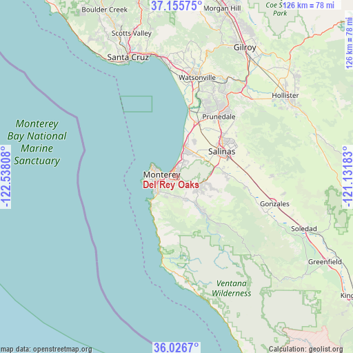
Del Rey Oaks GPS coordinates[2]
36° 35' 35.844" North, 121° 50' 5.82" West
| Map corner | latitude | longitude |
|---|---|---|
| Upper-left | 37.15575°, | -122.53808° |
| Center: | 36.59329°, | -121.83495° |
| Lower-right: | 36.0267°, | -121.13183° |
| Map W x H: | 125.5×125.5 km | = 78×78mi |
| max Lat: | 71.29058° ⇑67.7% North |
| Del Rey Oaks: | 36.59329° |
| min Lat: | ⇓32.3% South 19.06759° |
| min Long | Del Rey Oaks | max Long |
| -171.73463° | -121.83495° | -66.98998° |
| W 5.3%⇐ | ⇒94.7% E |
Elevation
Elevation of Del Rey Oaks is 19 m = 62 ft, and this is 275.8 m = 905 ft below average elevation for this country.
| Max E: |
3189 m = 10463 ft | 88.6% |
| Avg. | 294.8 m = 967 ft | |
| Del Rey Oaks | 19 m = 62 ft | |
Min E: |
-60 m = -197 ft | 11.4% |
See also: United States elevation on elevation.city.
Geographical zone
Del Rey Oaks is located in North temperate zone (between Tropic of Cancer and the Arctic Circle). Distance of this Northern Tropic circle is 1462.9 km =909 mi to South.| Distance of | km | miles | from Del Rey Oaks |
|---|---|---|---|
| North Pole | 5938.3 | 3689.9 | to North |
| Arctic Circle | 3332.4 | 2070.7 | to North |
| Tropic Cancer | 1462.9 | 909 | to South |
| Equator | 4068.8 | 2528.2 | to South |


Nearby cities:
15 places around Del Rey Oaks: (largest is in red/bold)
• Boronda
18.5 km =11.5 mi,  50°
50°
• Carmel Valley Village
11.5 km =7.1 mi,  147°
147°
• Carmel-by-the-Sea
9 km =5.6 mi,  241°
241°
• Castroville
20.4 km =12.7 mi,  19°
19°
• Chualar
28.4 km =17.6 mi,  95°
95°
• Del Monte Forest
10.1 km =6.3 mi,  265°
265°
• Elkhorn
27 km =16.8 mi, 18°
• Las Lomas
31.5 km =19.6 mi, 16°
• Marina
10.5 km =6.5 mi, 16°
• Monterey
5.4 km =3.4 mi,  278°
278°
• Pacific Grove
7.8 km =4.8 mi,  290°
290°
• Prunedale
25.1 km =15.6 mi,  35°
35°
• Salinas
18.6 km =11.6 mi,  59°
59°
• Seaside
2.5 km =1.6 mi,  323°
323°
• Spreckels
17.1 km =10.6 mi,  79°
79°
Sources, notices
• [Note1] Compared only with cities in United States existing in our database
• [Src1] Map data: © OpenStreetMap contributors (CC-BY-SA)
• [Src2] Other city data from geonames.org with taken over terms of usage.
• [Src3] Geographical zone / Annual Mean Temperature by Robert A. Rohde @ Wikipedia
