Del Monte Forest geodata
Del Monte Forest (California) is a populated place; located in United States in America/Los_Angeles (GMT-7) time zone. With population of 4,514 people, there are 7631 cities with bigger population in this country. Compared to other cities in United States, 67.8% of cities are located further ↑North; 94.9% of cities are located further →East and 76.3% of cities have higher elevation than Del Monte Forest. Note1


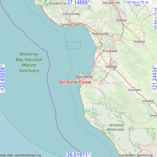
Del Monte Forest GPS coordinates[2]
36° 35' 10.86" North, 121° 56' 50.856" West
| Map corner | latitude | longitude |
|---|---|---|
| Upper-left | 37.14886°, | -122.65059° |
| Center: | 36.58635°, | -121.94746° |
| Lower-right: | 36.01971°, | -121.24434° |
| Map W x H: | 125.5×125.5 km | = 78×78mi |
| max Lat: | 71.29058° ⇑67.8% North |
| Del Monte Forest: | 36.58635° |
| min Lat: | ⇓32.2% South 19.06759° |
| min Long | Del Monte Fores | max Long |
| -171.73463° | -121.94746° | -66.98998° |
| W 5.1%⇐ | ⇒94.9% E |
Elevation
Elevation of Del Monte Forest is 64 m = 210 ft, and this is 230.8 m = 757 ft below average elevation for this country.
| Max E: |
3189 m = 10463 ft | 76.3% |
| Avg. | 294.8 m = 967 ft | |
| Del Monte Forest | 64 m = 210 ft | |
Min E: |
-60 m = -197 ft | 23.7% |
See also: United States elevation on elevation.city.
Geographical zone
Del Monte Forest is located in North temperate zone (between Tropic of Cancer and the Arctic Circle). Distance of this Northern Tropic circle is 1462.1 km =908.5 mi to South.| Distance of | km | miles | from Del Monte Forest |
|---|---|---|---|
| North Pole | 5939 | 3690.3 | to North |
| Arctic Circle | 3333.2 | 2071.2 | to North |
| Tropic Cancer | 1462.1 | 908.5 | to South |
| Equator | 4068 | 2527.7 | to South |


Nearby cities:
15 places around Del Monte Forest: (largest is in red/bold)
• Big Sur
37.3 km =23.2 mi,  160°
160°
• Boronda
27.3 km =17 mi,  62°
62°
• Carmel Valley Village
18.5 km =11.5 mi,  118°
118°
• Carmel-by-the-Sea
4.1 km =2.5 mi,  148°
148°
• Castroville
26.1 km =16.2 mi,  40°
40°
• Del Rey Oaks
10.1 km =6.3 mi,  85°
85°
• Elkhorn
32.3 km =20.1 mi,  34°
34°
• Las Lomas
36.3 km =22.6 mi, 31°
• Marina
16.9 km =10.5 mi,  49°
49°
• Monterey
5 km =3.1 mi,  71°
71°
• Pacific Grove
4.4 km =2.7 mi, 38°
• Prunedale
32.5 km =20.2 mi, 49°
• Salinas
28 km =17.4 mi, 68°
• Seaside
9 km =5.6 mi, 72°
• Spreckels
27.1 km =16.8 mi,  81°
81°
Sources, notices
• [Note1] Compared only with cities in United States existing in our database
• [Src1] Map data: © OpenStreetMap contributors (CC-BY-SA)
• [Src2] Other city data from geonames.org with taken over terms of usage.
• [Src3] Geographical zone / Annual Mean Temperature by Robert A. Rohde @ Wikipedia
