Bodfish geodata
Bodfish (California) is a populated place; located in United States in America/Los_Angeles (GMT-7) time zone. With population of 1,956 people, there are 12071 cities with bigger population in this country. Compared to other cities in United States, 72.3% of cities are located further ↑North; 91.6% of cities are located further →East and 92.2% of cities have lower elevation than Bodfish. Note1


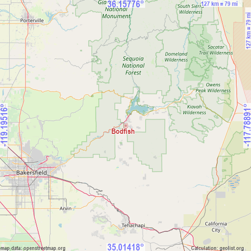
Bodfish GPS coordinates[2]
35° 35' 16.836" North, 118° 29' 31.308" West
| Map corner | latitude | longitude |
|---|---|---|
| Upper-left | 36.15776°, | -119.19516° |
| Center: | 35.58801°, | -118.49203° |
| Lower-right: | 35.01418°, | -117.78891° |
| Map W x H: | 127.2×127.2 km | = 79×79mi |
| max Lat: | 71.29058° ⇑72.3% North |
| Bodfish: | 35.58801° |
| min Lat: | ⇓27.7% South 19.06759° |
| min Long | Bodfish | max Long |
| -171.73463° | -118.49203° | -66.98998° |
| W 8.4%⇐ | ⇒91.6% E |
Elevation
Elevation of Bodfish is 818 m = 2684 ft, and this is 523.2 m = 1717 ft above average elevation for this country.
| Max E: |
3189 m = 10463 ft | 7.8% |
| Bodfish | 818 m 2684 ft | |
| Avg. | 294.8 m = 967 ft | |
Min E: |
-60 m = -197 ft | 92.2% |
See also: United States elevation on elevation.city.
Geographical zone
Bodfish is located in North temperate zone (between Tropic of Cancer and the Arctic Circle). Distance of this Northern Tropic circle is 1351.1 km =839.5 mi to South.| Distance of | km | miles | from Bodfish |
|---|---|---|---|
| North Pole | 6050 | 3759.3 | to North |
| Arctic Circle | 3444.2 | 2140.1 | to North |
| Tropic Cancer | 1351.1 | 839.5 | to South |
| Equator | 3957 | 2458.8 | to South |


Nearby cities:
15 places around Bodfish: (largest is in red/bold)
• Alta Sierra
16.9 km =10.5 mi,  340°
340°
• Arvin
52 km =32.3 mi,  215°
215°
• Bakersfield
53.3 km =33.1 mi,  243°
243°
• Bear Valley Springs
49.3 km =30.6 mi,  194°
194°
• Fuller Acres
49.7 km =30.9 mi,  229°
229°
• Golden Hills
49.5 km =30.8 mi,  179°
179°
• Kernville
19.5 km =12.1 mi,  18°
18°
• Lake Isabella
3.7 km =2.3 mi,  27°
27°
• Lamont
52.9 km =32.9 mi, 226°
• Mountain Mesa
9.7 km =6 mi,  53°
53°
• Oildale
51.3 km =31.9 mi,  248°
248°
• Squirrel Mountain Valley
8.4 km =5.2 mi,  62°
62°
• Tehachapi
50.8 km =31.6 mi, 175°
• Weldon
20.2 km =12.6 mi, 64°
• Wofford Heights
13.6 km =8.5 mi,  13°
13°
Sources, notices
• [Note1] Compared only with cities in United States existing in our database
• [Src1] Map data: © OpenStreetMap contributors (CC-BY-SA)
• [Src2] Other city data from geonames.org with taken over terms of usage.
• [Src3] Geographical zone / Annual Mean Temperature by Robert A. Rohde @ Wikipedia
