Bakersfield geodata
Bakersfield (California) is a seat of a second-order administrative division; located in United States in America/Los_Angeles (GMT-7) time zone. With population of 373,640 people, there are 57 cities with bigger population in this country. Compared to other cities in United States, 73.3% of cities are located further ↑North; 91.9% of cities are located further →East and 64.7% of cities have higher elevation than Bakersfield. Note1


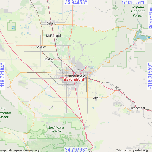
Bakersfield GPS coordinates[2]
35° 22' 23.844" North, 119° 1' 7.356" West
| Map corner | latitude | longitude |
|---|---|---|
| Upper-left | 35.94458°, | -119.72184° |
| Center: | 35.37329°, | -119.01871° |
| Lower-right: | 34.79793°, | -118.31559° |
| Map W x H: | 127.5×127.5 km | = 79.2×79.2mi |
| max Lat: | 71.29058° ⇑73.3% North |
| Bakersfield: | 35.37329° |
| min Lat: | ⇓26.7% South 19.06759° |
| min Long | Bakersfield | max Long |
| -171.73463° | -119.01871° | -66.98998° |
| W 8.1%⇐ | ⇒91.9% E |
Elevation
Elevation of Bakersfield is 130 m = 427 ft, and this is 164.8 m = 541 ft below average elevation for this country.
| Max E: |
3189 m = 10463 ft | 64.7% |
| Avg. | 294.8 m = 967 ft | |
| Bakersfield | 130 m = 427 ft | |
Min E: |
-60 m = -197 ft | 35.3% |
See also: Bakersfield elevation on elevation.city.
Geographical zone
Bakersfield is located in North temperate zone (between Tropic of Cancer and the Arctic Circle). Distance of this Northern Tropic circle is 1327.2 km =824.7 mi to South.| Distance of | km | miles | from Bakersfield |
|---|---|---|---|
| North Pole | 6073.9 | 3774.1 | to North |
| Arctic Circle | 3468 | 2154.9 | to North |
| Tropic Cancer | 1327.2 | 824.7 | to South |
| Equator | 3933.1 | 2443.9 | to South |


Nearby cities:
15 places around Bakersfield: (largest is in red/bold)
• Arvin
25.1 km =15.6 mi,  136°
136°
• Buttonwillow
41 km =25.5 mi,  274°
274°
• Dustin Acres
37.8 km =23.5 mi,  243°
243°
• Fuller Acres
12.7 km =7.9 mi,  130°
130°
• Greenacres
8.3 km =5.2 mi,  277°
277°
• Greenfield
11.7 km =7.3 mi,  172°
172°
• Lamont
15.8 km =9.8 mi, 143°
• McFarland
38.9 km =24.2 mi,  330°
330°
• Oildale
5.2 km =3.2 mi,  359°
359°
• Rosedale
11.5 km =7.1 mi, 275°
• Shafter
26.9 km =16.7 mi,  301°
301°
• Smith Corner
26.3 km =16.3 mi, 296°
• Valley Acres
39.8 km =24.7 mi, 242°
• Wasco
38.1 km =23.7 mi,  310°
310°
• Weedpatch
17.7 km =11 mi,  147°
147°
Sources, notices
• [Note1] Compared only with cities in United States existing in our database
• [Src1] Map data: © OpenStreetMap contributors (CC-BY-SA)
• [Src2] Other city data from geonames.org with taken over terms of usage.
• [Src3] Geographical zone / Annual Mean Temperature by Robert A. Rohde @ Wikipedia
