Oildale geodata
Oildale (California) is a populated place; located in United States in America/Los_Angeles (GMT-7) time zone. With population of 32,684 people, there are 1524 cities with bigger population in this country. Compared to other cities in United States, 73.1% of cities are located further ↑North; 91.9% of cities are located further →East and 61.5% of cities have higher elevation than Oildale. Note1


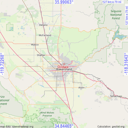
Oildale GPS coordinates[2]
35° 25' 10.848" North, 119° 1' 10.38" West
| Map corner | latitude | longitude |
|---|---|---|
| Upper-left | 35.99063°, | -119.72268° |
| Center: | 35.41968°, | -119.01955° |
| Lower-right: | 34.84465°, | -118.31643° |
| Map W x H: | 127.4×127.4 km | = 79.2×79.2mi |
| max Lat: | 71.29058° ⇑73.1% North |
| Oildale: | 35.41968° |
| min Lat: | ⇓26.9% South 19.06759° |
| min Long | Oildale | max Long |
| -171.73463° | -119.01955° | -66.98998° |
| W 8.1%⇐ | ⇒91.9% E |
Elevation
Elevation of Oildale is 147 m = 482 ft, and this is 147.8 m = 485 ft below average elevation for this country.
| Max E: |
3189 m = 10463 ft | 61.5% |
| Avg. | 294.8 m = 967 ft | |
| Oildale | 147 m = 482 ft | |
Min E: |
-60 m = -197 ft | 38.5% |
See also: United States elevation on elevation.city.
Geographical zone
Oildale is located in North temperate zone (between Tropic of Cancer and the Arctic Circle). Distance of this Northern Tropic circle is 1332.4 km =827.9 mi to South.| Distance of | km | miles | from Oildale |
|---|---|---|---|
| North Pole | 6068.8 | 3771 | to North |
| Arctic Circle | 3462.9 | 2151.7 | to North |
| Tropic Cancer | 1332.4 | 827.9 | to South |
| Equator | 3938.3 | 2447.1 | to South |


Nearby cities:
15 places around Oildale: (largest is in red/bold)
• Arvin
29.1 km =18.1 mi,  143°
143°
• Bakersfield
5.2 km =3.2 mi,  179°
179°
• Buttonwillow
40.8 km =25.4 mi,  267°
267°
• Dustin Acres
40.4 km =25.1 mi,  236°
236°
• Fuller Acres
16.5 km =10.3 mi, 143°
• Greenacres
9.1 km =5.7 mi, 243°
• Greenfield
16.8 km =10.4 mi,  174°
174°
• Lamont
20.2 km =12.6 mi,  151°
151°
• McFarland
34.4 km =21.4 mi,  326°
326°
• Rosedale
12.1 km =7.5 mi,  250°
250°
• Shafter
24.5 km =15.2 mi,  291°
291°
• Smith Corner
24.4 km =15.2 mi, 285°
• Valley Acres
42.4 km =26.3 mi, 235°
• Wasco
35 km =21.7 mi,  303°
303°
• Weedpatch
22.3 km =13.9 mi, 154°
Sources, notices
• [Note1] Compared only with cities in United States existing in our database
• [Src1] Map data: © OpenStreetMap contributors (CC-BY-SA)
• [Src2] Other city data from geonames.org with taken over terms of usage.
• [Src3] Geographical zone / Annual Mean Temperature by Robert A. Rohde @ Wikipedia
