Tehachapi geodata
Tehachapi (California) is a populated place; located in United States in America/Los_Angeles (GMT-7) time zone. With population of 13,021 people, there are 3664 cities with bigger population in this country. Compared to other cities in United States, 74.7% of cities are located further ↑North; 91.5% of cities are located further →East and 94.6% of cities have lower elevation than Tehachapi. Note1


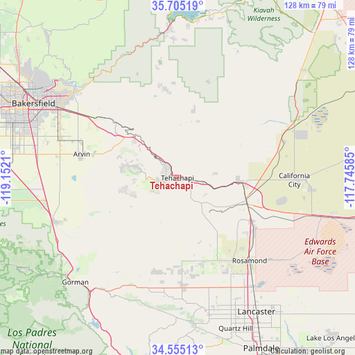
Tehachapi GPS coordinates[2]
35° 7' 55.884" North, 118° 26' 56.292" West
| Map corner | latitude | longitude |
|---|---|---|
| Upper-left | 35.70519°, | -119.1521° |
| Center: | 35.13219°, | -118.44897° |
| Lower-right: | 34.55513°, | -117.74585° |
| Map W x H: | 127.9×127.9 km | = 79.5×79.5mi |
| max Lat: | 71.29058° ⇑74.7% North |
| Tehachapi: | 35.13219° |
| min Lat: | ⇓25.3% South 19.06759° |
| min Long | Tehachapi | max Long |
| -171.73463° | -118.44897° | -66.98998° |
| W 8.5%⇐ | ⇒91.5% E |
Elevation
Elevation of Tehachapi is 1212 m = 3976 ft, and this is 917.2 m = 3009 ft above average elevation for this country.
| Max E: |
3189 m = 10463 ft | 5.4% |
| Tehachapi | 1212 m 3976 ft | |
| Avg. | 294.8 m = 967 ft | |
Min E: |
-60 m = -197 ft | 94.6% |
See also: United States elevation on elevation.city.
Geographical zone
Tehachapi is located in North temperate zone (between Tropic of Cancer and the Arctic Circle). Distance of this Northern Tropic circle is 1300.4 km =808 mi to South.| Distance of | km | miles | from Tehachapi |
|---|---|---|---|
| North Pole | 6100.7 | 3790.8 | to North |
| Arctic Circle | 3494.8 | 2171.6 | to North |
| Tropic Cancer | 1300.4 | 808 | to South |
| Equator | 3906.3 | 2427.3 | to South |


Nearby cities:
15 places around Tehachapi: (largest is in red/bold)
• Arvin
35.5 km =22.1 mi,  283°
283°
• Bear Valley Springs
16.6 km =10.3 mi, 280°
• Bodfish
50.8 km =31.6 mi,  355°
355°
• California City
42.1 km =26.2 mi,  90°
90°
• Edwards Air Force Base
52.6 km =32.7 mi,  117°
117°
• Fuller Acres
46 km =28.6 mi,  293°
293°
• Golden Hills
3.9 km =2.4 mi, 286°
• Greenfield
52.6 km =32.7 mi, 286°
• Lake Hughes
50.6 km =31.4 mi,  179°
179°
• Lamont
44.6 km =27.7 mi, 288°
• Lebec
49.8 km =30.9 mi,  229°
229°
• Mojave
26.5 km =16.5 mi,  109°
109°
• Rosamond
39.6 km =24.6 mi,  138°
138°
• Stallion Springs
18.3 km =11.4 mi,  254°
254°
• Weedpatch
44 km =27.3 mi, 285°
Sources, notices
• [Note1] Compared only with cities in United States existing in our database
• [Src1] Map data: © OpenStreetMap contributors (CC-BY-SA)
• [Src2] Other city data from geonames.org with taken over terms of usage.
• [Src3] Geographical zone / Annual Mean Temperature by Robert A. Rohde @ Wikipedia
