Fillmore geodata
Fillmore (California) is a populated place; located in United States in America/Los_Angeles (GMT-7) time zone. With population of 15,548 people, there are 3135 cities with bigger population in this country. Compared to other cities in United States, 78.1% of cities are located further ↑North; 91.8% of cities are located further →East and 62.2% of cities have higher elevation than Fillmore. Note1


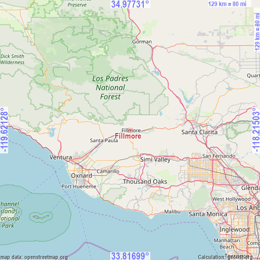
Fillmore GPS coordinates[2]
34° 23' 56.976" North, 118° 55' 5.34" West
| Map corner | latitude | longitude |
|---|---|---|
| Upper-left | 34.97731°, | -119.62128° |
| Center: | 34.39916°, | -118.91815° |
| Lower-right: | 33.81699°, | -118.21503° |
| Map W x H: | 129×129 km | = 80.2×80.2mi |
| max Lat: | 71.29058° ⇑78.1% North |
| Fillmore: | 34.39916° |
| min Lat: | ⇓21.9% South 19.06759° |
| min Long | Fillmore | max Long |
| -171.73463° | -118.91815° | -66.98998° |
| W 8.2%⇐ | ⇒91.8% E |
Elevation
Elevation of Fillmore is 143 m = 469 ft, and this is 151.8 m = 498 ft below average elevation for this country.
| Max E: |
3189 m = 10463 ft | 62.2% |
| Avg. | 294.8 m = 967 ft | |
| Fillmore | 143 m = 469 ft | |
Min E: |
-60 m = -197 ft | 37.8% |
See also: United States elevation on elevation.city.
Geographical zone
Fillmore is located in North temperate zone (between Tropic of Cancer and the Arctic Circle). Distance of this Northern Tropic circle is 1218.9 km =757.4 mi to South.| Distance of | km | miles | from Fillmore |
|---|---|---|---|
| North Pole | 6182.2 | 3841.4 | to North |
| Arctic Circle | 3576.3 | 2222.2 | to North |
| Tropic Cancer | 1218.9 | 757.4 | to South |
| Equator | 3824.8 | 2376.6 | to South |


Nearby cities:
15 places around Fillmore: (largest is in red/bold)
• Camarillo
23.1 km =14.4 mi,  208°
208°
• Casa Conejo
24.1 km =15 mi,  185°
185°
• Castaic
28.9 km =18 mi,  69°
69°
• El Rio
29 km =18 mi,  231°
231°
• Moorpark
13.1 km =8.1 mi,  165°
165°
• Oak Park
28.3 km =17.6 mi,  149°
149°
• Piru
11.5 km =7.1 mi,  81°
81°
• Santa Paula
13.9 km =8.6 mi,  248°
248°
• Santa Susana
23.9 km =14.9 mi,  126°
126°
• Saticoy
24.9 km =15.5 mi,  238°
238°
• Simi Valley
19.1 km =11.9 mi,  138°
138°
• Thousand Oaks
26.5 km =16.5 mi,  163°
163°
• Val Verde
24.4 km =15.2 mi, 77°
• Valencia
28.7 km =17.8 mi, 80°
• Westlake Village
30 km =18.6 mi, 159°
Sources, notices
• [Note1] Compared only with cities in United States existing in our database
• [Src1] Map data: © OpenStreetMap contributors (CC-BY-SA)
• [Src2] Other city data from geonames.org with taken over terms of usage.
• [Src3] Geographical zone / Annual Mean Temperature by Robert A. Rohde @ Wikipedia
