Biola geodata
Biola (California) is a populated place; located in United States in America/Los_Angeles (GMT-7) time zone. With population of 1,623 people, there are 13207 cities with bigger population in this country. Compared to other cities in United States, 66.9% of cities are located further ↑North; 92.8% of cities are located further →East and 73.7% of cities have higher elevation than Biola. Note1


Biola GPS coordinates[2]
36° 48' 7.812" North, 120° 0' 58.572" West
| Map corner | latitude | longitude |
|---|---|---|
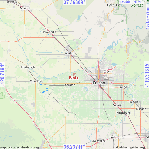
| Upper-left | 37.36309°, | -120.7194° |
| Center: | 36.80217°, | -120.01627° |
| Lower-right: | 36.23711°, | -119.31315° |
| Map W x H: | 125.2×125.2 km | = 77.8×77.8mi |
| max Lat: | 71.29058° ⇑66.9% North |
| Biola: | 36.80217° |
| min Lat: | ⇓33.1% South 19.06759° |
| min Long | Biola | max Long |
| -171.73463° | -120.01627° | -66.98998° |
| W 7.2%⇐ | ⇒92.8% E |
Elevation
Elevation of Biola is 79 m = 259 ft, and this is 215.8 m = 708 ft below average elevation for this country.
| Max E: |
3189 m = 10463 ft | 73.7% |
| Avg. | 294.8 m = 967 ft | |
| Biola | 79 m = 259 ft | |
Min E: |
-60 m = -197 ft | 26.3% |
See also: United States elevation on elevation.city.
Geographical zone
Biola is located in North temperate zone (between Tropic of Cancer and the Arctic Circle). Distance of this Northern Tropic circle is 1486.1 km =923.4 mi to South.| Distance of | km | miles | from Biola |
|---|---|---|---|
| North Pole | 5915 | 3675.4 | to North |
| Arctic Circle | 3309.2 | 2056.2 | to North |
| Tropic Cancer | 1486.1 | 923.4 | to South |
| Equator | 4092 | 2542.7 | to South |


Nearby cities:
15 places around Biola: (largest is in red/bold)
• Bonadelle Ranchos-Madera Ranchos
23.9 km =14.9 mi,  31°
31°
• Calwa
25.1 km =15.6 mi,  113°
113°
• Clovis
28 km =17.4 mi,  84°
84°
• Easton
26.3 km =16.3 mi,  130°
130°
• Fresno
22.5 km =14 mi, 105°
• Kerman
9.6 km =6 mi,  203°
203°
• Madera
18.1 km =11.2 mi,  347°
347°
• Madera Acres
24.5 km =15.2 mi, 349°
• Old Fig Garden
18.8 km =11.7 mi,  91°
91°
• Parksdale
16.1 km =10 mi,  357°
357°
• Parkwood
14.1 km =8.8 mi, 349°
• Rolling Hills
22.5 km =14 mi,  59°
59°
• San Joaquin
26.6 km =16.5 mi,  215°
215°
• Tranquillity
27.1 km =16.8 mi,  231°
231°
• West Park
17.9 km =11.1 mi,  124°
124°
Sources, notices
• [Note1] Compared only with cities in United States existing in our database
• [Src1] Map data: © OpenStreetMap contributors (CC-BY-SA)
• [Src2] Other city data from geonames.org with taken over terms of usage.
• [Src3] Geographical zone / Annual Mean Temperature by Robert A. Rohde @ Wikipedia
