Crestline geodata
Crestline (California) is a populated place; located in United States in America/Los_Angeles (GMT-7) time zone. With population of 10,770 people, there are 4243 cities with bigger population in this country. Compared to other cities in United States, 78.7% of cities are located further ↑North; 90.2% of cities are located further →East and 96.1% of cities have lower elevation than Crestline. Note1


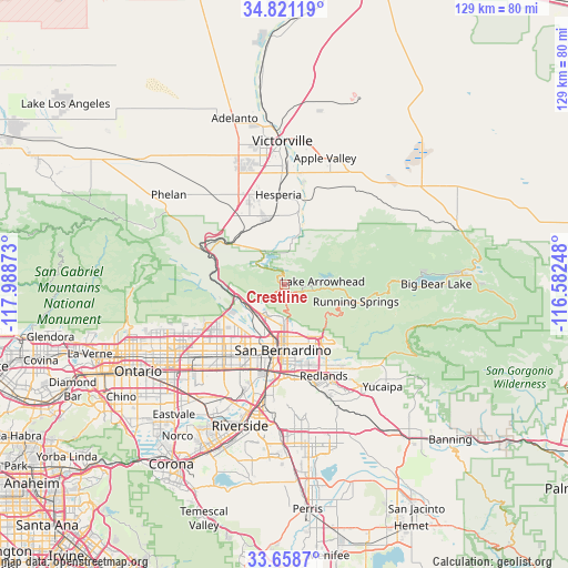
Crestline GPS coordinates[2]
34° 14' 31.02" North, 117° 17' 8.16" West
| Map corner | latitude | longitude |
|---|---|---|
| Upper-left | 34.82119°, | -117.98873° |
| Center: | 34.24195°, | -117.2856° |
| Lower-right: | 33.6587°, | -116.58248° |
| Map W x H: | 129.3×129.3 km | = 80.3×80.3mi |
| max Lat: | 71.29058° ⇑78.7% North |
| Crestline: | 34.24195° |
| min Lat: | ⇓21.3% South 19.06759° |
| min Long | Crestline | max Long |
| -171.73463° | -117.2856° | -66.98998° |
| W 9.8%⇐ | ⇒90.2% E |
Elevation
Elevation of Crestline is 1415 m = 4642 ft, and this is 1120.2 m = 3675 ft above average elevation for this country.
| Max E: |
3189 m = 10463 ft | 3.9% |
| Crestline | 1415 m 4642 ft | |
| Avg. | 294.8 m = 967 ft | |
Min E: |
-60 m = -197 ft | 96.1% |
See also: United States elevation on elevation.city.
Geographical zone
Crestline is located in North temperate zone (between Tropic of Cancer and the Arctic Circle). Distance of this Northern Tropic circle is 1201.4 km =746.5 mi to South.| Distance of | km | miles | from Crestline |
|---|---|---|---|
| North Pole | 6199.7 | 3852.3 | to North |
| Arctic Circle | 3593.8 | 2233.1 | to North |
| Tropic Cancer | 1201.4 | 746.5 | to South |
| Equator | 3807.3 | 2365.7 | to South |


Nearby cities:
15 places around Crestline: (largest is in red/bold)
• Bloomington
21.6 km =13.4 mi,  207°
207°
• Colton
18.9 km =11.7 mi,  187°
187°
• Fontana
21.6 km =13.4 mi,  219°
219°
• Grand Terrace
23.3 km =14.5 mi, 186°
• Hesperia
20.6 km =12.8 mi,  356°
356°
• Highland
14.5 km =9 mi,  150°
150°
• Lake Arrowhead
8.9 km =5.5 mi,  85°
85°
• Loma Linda
21.6 km =13.4 mi,  174°
174°
• Lytle Creek
19.8 km =12.3 mi,  275°
275°
• Muscoy
11.1 km =6.9 mi, 208°
• Oak Hills
18 km =11.2 mi,  330°
330°
• Redlands
22.8 km =14.2 mi,  155°
155°
• Rialto
17 km =10.6 mi, 207°
• Running Springs
16.7 km =10.4 mi,  103°
103°
• San Bernardino
14.9 km =9.3 mi,  181°
181°
Sources, notices
• [Note1] Compared only with cities in United States existing in our database
• [Src1] Map data: © OpenStreetMap contributors (CC-BY-SA)
• [Src2] Other city data from geonames.org with taken over terms of usage.
• [Src3] Geographical zone / Annual Mean Temperature by Robert A. Rohde @ Wikipedia
