Highland geodata
Highland (California) is a populated place; located in United States in America/Los_Angeles (GMT-7) time zone. With population of 54,854 people, there are 845 cities with bigger population in this country. Compared to other cities in United States, 79.4% of cities are located further ↑North; 90% of cities are located further →East and 83.9% of cities have lower elevation than Highland. Note1


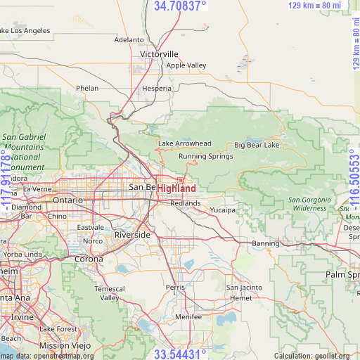
Highland GPS coordinates[2]
34° 7' 42.024" North, 117° 12' 31.14" West
| Map corner | latitude | longitude |
|---|---|---|
| Upper-left | 34.70837°, | -117.91178° |
| Center: | 34.12834°, | -117.20865° |
| Lower-right: | 33.54431°, | -116.50553° |
| Map W x H: | 129.4×129.4 km | = 80.4×80.4mi |
| max Lat: | 71.29058° ⇑79.4% North |
| Highland: | 34.12834° |
| min Lat: | ⇓20.6% South 19.06759° |
| min Long | Highland | max Long |
| -171.73463° | -117.20865° | -66.98998° |
| W 10%⇐ | ⇒90% E |
Elevation
Elevation of Highland is 403 m = 1322 ft, and this is 108.2 m = 355 ft above average elevation for this country.
| Max E: |
3189 m = 10463 ft | 16.1% |
| Highland | 403 m 1322 ft | |
| Avg. | 294.8 m = 967 ft | |
Min E: |
-60 m = -197 ft | 83.9% |
See also: Highland elevation on elevation.city.
Geographical zone
Highland is located in North temperate zone (between Tropic of Cancer and the Arctic Circle). Distance of this Northern Tropic circle is 1188.8 km =738.7 mi to South.| Distance of | km | miles | from Highland |
|---|---|---|---|
| North Pole | 6212.3 | 3860.1 | to North |
| Arctic Circle | 3606.5 | 2241 | to North |
| Tropic Cancer | 1188.8 | 738.7 | to South |
| Equator | 3794.7 | 2357.9 | to South |


Nearby cities:
15 places around Highland: (largest is in red/bold)
• Bloomington
18.4 km =11.4 mi,  249°
249°
• Calimesa
19.3 km =12 mi,  135°
135°
• Colton
11.4 km =7.1 mi,  237°
237°
• Crestline
14.5 km =9 mi,  330°
330°
• Grand Terrace
14.3 km =8.9 mi,  222°
222°
• Highgrove
17 km =10.6 mi, 222°
• Lake Arrowhead
13.5 km =8.4 mi,  7°
7°
• Loma Linda
10.1 km =6.3 mi,  208°
208°
• Mentone
9.4 km =5.8 mi,  133°
133°
• Muscoy
12.8 km =8 mi,  282°
282°
• Redlands
8.4 km =5.2 mi,  163°
163°
• Rialto
15.1 km =9.4 mi,  260°
260°
• Running Springs
12.7 km =7.9 mi,  46°
46°
• San Bernardino
7.8 km =4.8 mi, 253°
• Yucaipa
18.5 km =11.5 mi,  124°
124°
Sources, notices
• [Note1] Compared only with cities in United States existing in our database
• [Src1] Map data: © OpenStreetMap contributors (CC-BY-SA)
• [Src2] Other city data from geonames.org with taken over terms of usage.
• [Src3] Geographical zone / Annual Mean Temperature by Robert A. Rohde @ Wikipedia
