Muscoy geodata
Muscoy (California) is a populated place; located in United States in America/Los_Angeles (GMT-7) time zone. With population of 10,644 people, there are 4286 cities with bigger population in this country. Compared to other cities in United States, 79.2% of cities are located further ↑North; 90.2% of cities are located further →East and 84.9% of cities have lower elevation than Muscoy. Note1


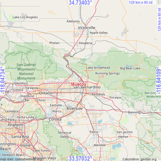
Muscoy GPS coordinates[2]
34° 9' 15.048" North, 117° 20' 39.156" West
| Map corner | latitude | longitude |
|---|---|---|
| Upper-left | 34.73403°, | -118.04734° |
| Center: | 34.15418°, | -117.34421° |
| Lower-right: | 33.57032°, | -116.64109° |
| Map W x H: | 129.4×129.4 km | = 80.4×80.4mi |
| max Lat: | 71.29058° ⇑79.2% North |
| Muscoy: | 34.15418° |
| min Lat: | ⇓20.8% South 19.06759° |
| min Long | Muscoy | max Long |
| -171.73463° | -117.34421° | -66.98998° |
| W 9.8%⇐ | ⇒90.2% E |
Elevation
Elevation of Muscoy is 422 m = 1385 ft, and this is 127.2 m = 417 ft above average elevation for this country.
| Max E: |
3189 m = 10463 ft | 15.1% |
| Muscoy | 422 m 1385 ft | |
| Avg. | 294.8 m = 967 ft | |
Min E: |
-60 m = -197 ft | 84.9% |
See also: United States elevation on elevation.city.
Geographical zone
Muscoy is located in North temperate zone (between Tropic of Cancer and the Arctic Circle). Distance of this Northern Tropic circle is 1191.7 km =740.5 mi to South.| Distance of | km | miles | from Muscoy |
|---|---|---|---|
| North Pole | 6209.5 | 3858.4 | to North |
| Arctic Circle | 3603.6 | 2239.2 | to North |
| Tropic Cancer | 1191.7 | 740.5 | to South |
| Equator | 3797.6 | 2359.7 | to South |


Nearby cities:
15 places around Muscoy: (largest is in red/bold)
• Bloomington
10.5 km =6.5 mi,  207°
207°
• Colton
9.4 km =5.8 mi,  162°
162°
• Crestline
11.1 km =6.9 mi,  28°
28°
• Fontana
10.8 km =6.7 mi,  230°
230°
• Grand Terrace
13.7 km =8.5 mi,  168°
168°
• Highgrove
15.4 km =9.6 mi,  176°
176°
• Highland
12.8 km =8 mi,  102°
102°
• Lake Arrowhead
17.7 km =11 mi,  53°
53°
• Loma Linda
14 km =8.7 mi,  146°
146°
• Lytle Creek
18.5 km =11.5 mi,  309°
309°
• Redlands
18.5 km =11.5 mi,  126°
126°
• Rialto
5.8 km =3.6 mi,  204°
204°
• Rubidoux
18.5 km =11.5 mi, 197°
• San Bernardino
7.1 km =4.4 mi,  135°
135°
• Sunnyslope
17.8 km =11.1 mi, 207°
Sources, notices
• [Note1] Compared only with cities in United States existing in our database
• [Src1] Map data: © OpenStreetMap contributors (CC-BY-SA)
• [Src2] Other city data from geonames.org with taken over terms of usage.
• [Src3] Geographical zone / Annual Mean Temperature by Robert A. Rohde @ Wikipedia
