Lytle Creek geodata
Lytle Creek (California) is a populated place; located in United States in America/Los_Angeles (GMT-7) time zone. With population of 701 people, there are 18667 cities with bigger population in this country. Compared to other cities in United States, 78.6% of cities are located further ↑North; 90.4% of cities are located further →East and 93.7% of cities have lower elevation than Lytle Creek. Note1


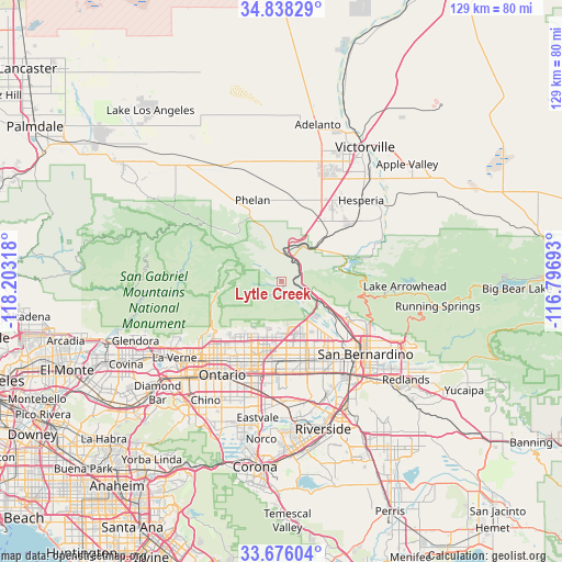
Lytle Creek GPS coordinates[2]
34° 15' 33.012" North, 117° 30' 0.18" West
| Map corner | latitude | longitude |
|---|---|---|
| Upper-left | 34.83829°, | -118.20318° |
| Center: | 34.25917°, | -117.50005° |
| Lower-right: | 33.67604°, | -116.79693° |
| Map W x H: | 129.2×129.2 km | = 80.3×80.3mi |
| max Lat: | 71.29058° ⇑78.6% North |
| Lytle Creek: | 34.25917° |
| min Lat: | ⇓21.4% South 19.06759° |
| min Long | Lytle Creek | max Long |
| -171.73463° | -117.50005° | -66.98998° |
| W 9.6%⇐ | ⇒90.4% E |
Elevation
Elevation of Lytle Creek is 1044 m = 3425 ft, and this is 749.2 m = 2458 ft above average elevation for this country.
| Max E: |
3189 m = 10463 ft | 6.3% |
| Lytle Creek | 1044 m 3425 ft | |
| Avg. | 294.8 m = 967 ft | |
Min E: |
-60 m = -197 ft | 93.7% |
See also: United States elevation on elevation.city.
Geographical zone
Lytle Creek is located in North temperate zone (between Tropic of Cancer and the Arctic Circle). Distance of this Northern Tropic circle is 1203.3 km =747.7 mi to South.| Distance of | km | miles | from Lytle Creek |
|---|---|---|---|
| North Pole | 6197.8 | 3851.1 | to North |
| Arctic Circle | 3591.9 | 2231.9 | to North |
| Tropic Cancer | 1203.3 | 747.7 | to South |
| Equator | 3809.3 | 2367 | to South |


Nearby cities:
15 places around Lytle Creek: (largest is in red/bold)
• Bloomington
23.1 km =14.4 mi,  155°
155°
• Crestline
19.8 km =12.3 mi,  95°
95°
• Fontana
19.5 km =12.1 mi, 162°
• Hesperia
26.1 km =16.2 mi,  44°
44°
• Muscoy
18.5 km =11.5 mi,  129°
129°
• Oak Hills
17.6 km =10.9 mi, 38°
• Ontario
25.8 km =16 mi,  212°
212°
• Phelan
19.7 km =12.2 mi,  340°
340°
• Piñon Hills
23.6 km =14.7 mi,  325°
325°
• Rancho Cucamonga
19 km =11.8 mi, 206°
• Rialto
20.8 km =12.9 mi,  144°
144°
• San Antonio Heights
18.4 km =11.4 mi,  231°
231°
• San Bernardino
25.6 km =15.9 mi, 130°
• Upland
22.6 km =14 mi,  217°
217°
• Wrightwood
16.7 km =10.4 mi,  312°
312°
Sources, notices
• [Note1] Compared only with cities in United States existing in our database
• [Src1] Map data: © OpenStreetMap contributors (CC-BY-SA)
• [Src2] Other city data from geonames.org with taken over terms of usage.
• [Src3] Geographical zone / Annual Mean Temperature by Robert A. Rohde @ Wikipedia
