Redlands geodata
Redlands (California) is a populated place; located in United States in America/Los_Angeles (GMT-7) time zone. With population of 71,035 people, there are 587 cities with bigger population in this country. Compared to other cities in United States, 79.9% of cities are located further ↑North; 90% of cities are located further →East and 84.7% of cities have lower elevation than Redlands. Note1


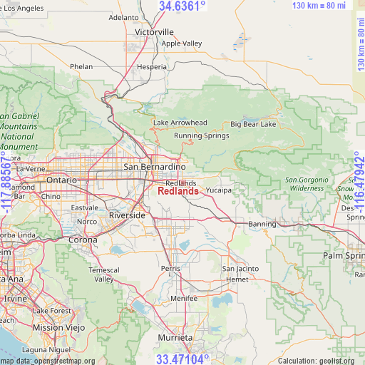
Redlands GPS coordinates[2]
34° 3' 20.052" North, 117° 10' 57.144" West
| Map corner | latitude | longitude |
|---|---|---|
| Upper-left | 34.6361°, | -117.88567° |
| Center: | 34.05557°, | -117.18254° |
| Lower-right: | 33.47104°, | -116.47942° |
| Map W x H: | 129.5×129.5 km | = 80.5×80.5mi |
| max Lat: | 71.29058° ⇑79.9% North |
| Redlands: | 34.05557° |
| min Lat: | ⇓20.1% South 19.06759° |
| min Long | Redlands | max Long |
| -171.73463° | -117.18254° | -66.98998° |
| W 10%⇐ | ⇒90% E |
Elevation
Elevation of Redlands is 417 m = 1368 ft, and this is 122.2 m = 401 ft above average elevation for this country.
| Max E: |
3189 m = 10463 ft | 15.3% |
| Redlands | 417 m 1368 ft | |
| Avg. | 294.8 m = 967 ft | |
Min E: |
-60 m = -197 ft | 84.7% |
See also: Redlands elevation on elevation.city.
Geographical zone
Redlands is located in North temperate zone (between Tropic of Cancer and the Arctic Circle). Distance of this Northern Tropic circle is 1180.7 km =733.7 mi to South.| Distance of | km | miles | from Redlands |
|---|---|---|---|
| North Pole | 6220.4 | 3865.2 | to North |
| Arctic Circle | 3614.5 | 2245.9 | to North |
| Tropic Cancer | 1180.7 | 733.7 | to South |
| Equator | 3786.6 | 2352.9 | to South |


Nearby cities:
15 places around Redlands: (largest is in red/bold)
• Bloomington
19.7 km =12.2 mi,  274°
274°
• Calimesa
12.5 km =7.8 mi,  117°
117°
• Colton
12.2 km =7.6 mi,  279°
279°
• Grand Terrace
12.3 km =7.6 mi,  258°
258°
• Highgrove
14.6 km =9.1 mi,  252°
252°
• Highland
8.4 km =5.2 mi,  343°
343°
• Loma Linda
7.3 km =4.5 mi, 263°
• March Air Force Base
19.6 km =12.2 mi,  202°
202°
• Mentone
4.7 km =2.9 mi,  70°
70°
• Moreno Valley
13.9 km =8.6 mi, 198°
• Muscoy
18.5 km =11.5 mi,  306°
306°
• Rialto
18.2 km =11.3 mi,  288°
288°
• Running Springs
18.2 km =11.3 mi,  21°
21°
• San Bernardino
11.5 km =7.1 mi,  300°
300°
• Yucaipa
13.1 km =8.1 mi,  100°
100°
Sources, notices
• [Note1] Compared only with cities in United States existing in our database
• [Src1] Map data: © OpenStreetMap contributors (CC-BY-SA)
• [Src2] Other city data from geonames.org with taken over terms of usage.
• [Src3] Geographical zone / Annual Mean Temperature by Robert A. Rohde @ Wikipedia
