Hawthorne geodata
Hawthorne (California) is a populated place; located in United States in America/Los_Angeles (GMT-7) time zone. With population of 88,451 people, there are 420 cities with bigger population in this country. Compared to other cities in United States, 80.8% of cities are located further ↑North; 91.4% of cities are located further →East and 86.6% of cities have higher elevation than Hawthorne. Note1


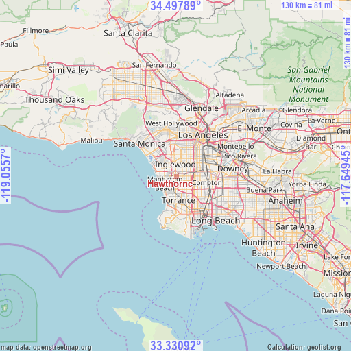
Hawthorne GPS coordinates[2]
33° 54' 59.04" North, 118° 21' 9.252" West
| Map corner | latitude | longitude |
|---|---|---|
| Upper-left | 34.49789°, | -119.0557° |
| Center: | 33.9164°, | -118.35257° |
| Lower-right: | 33.33092°, | -117.64945° |
| Map W x H: | 129.8×129.8 km | = 80.7×80.7mi |
| max Lat: | 71.29058° ⇑80.8% North |
| Hawthorne: | 33.9164° |
| min Lat: | ⇓19.2% South 19.06759° |
| min Long | Hawthorne | max Long |
| -171.73463° | -118.35257° | -66.98998° |
| W 8.6%⇐ | ⇒91.4% E |
Elevation
Elevation of Hawthorne is 24 m = 79 ft, and this is 270.8 m = 888 ft below average elevation for this country.
| Max E: |
3189 m = 10463 ft | 86.6% |
| Avg. | 294.8 m = 967 ft | |
| Hawthorne | 24 m = 79 ft | |
Min E: |
-60 m = -197 ft | 13.4% |
See also: Hawthorne elevation on elevation.city.
Geographical zone
Hawthorne is located in North temperate zone (between Tropic of Cancer and the Arctic Circle). Distance of this Northern Tropic circle is 1165.2 km =724 mi to South.| Distance of | km | miles | from Hawthorne |
|---|---|---|---|
| North Pole | 6235.9 | 3874.8 | to North |
| Arctic Circle | 3630 | 2255.6 | to North |
| Tropic Cancer | 1165.2 | 724 | to South |
| Equator | 3771.2 | 2343.3 | to South |


Nearby cities:
15 places around Hawthorne: (largest is in red/bold)
• Alondra Park
3.6 km =2.2 mi,  146°
146°
• Del Aire
1.6 km =1 mi,  268°
268°
• El Segundo
5.9 km =3.7 mi, 273°
• Gardena
5.1 km =3.2 mi,  127°
127°
• Hermosa Beach
7.4 km =4.6 mi,  215°
215°
• Inglewood
5 km =3.1 mi,  359°
359°
• Ladera Heights
8.9 km =5.5 mi,  346°
346°
• Lawndale
3.2 km =2 mi,  180°
180°
• Lennox
2.4 km =1.5 mi, 359°
• Manhattan Beach
6.4 km =4 mi,  236°
236°
• Redondo Beach
8.2 km =5.1 mi,  203°
203°
• View Park-Windsor Hills
8.8 km =5.5 mi,  2°
2°
• West Athens
4.6 km =2.9 mi,  80°
80°
• West Rancho Dominguez
8 km =5 mi,  108°
108°
• Westmont
5.4 km =3.4 mi,  59°
59°
Sources, notices
• [Note1] Compared only with cities in United States existing in our database
• [Src1] Map data: © OpenStreetMap contributors (CC-BY-SA)
• [Src2] Other city data from geonames.org with taken over terms of usage.
• [Src3] Geographical zone / Annual Mean Temperature by Robert A. Rohde @ Wikipedia
