Inverness geodata
Inverness (California) is a populated place; located in United States in America/Los_Angeles (GMT-7) time zone. With population of 1,304 people, there are 14578 cities with bigger population in this country. Compared to other cities in United States, 61.1% of cities are located further ↑North; 97.6% of cities are located further →East and 91.5% of cities have higher elevation than Inverness. Note1


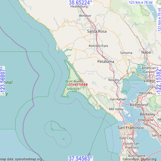
Inverness GPS coordinates[2]
38° 6' 3.708" North, 122° 51' 24.984" West
| Map corner | latitude | longitude |
|---|---|---|
| Upper-left | 38.65224°, | -123.56007° |
| Center: | 38.10103°, | -122.85694° |
| Lower-right: | 37.54563°, | -122.15382° |
| Map W x H: | 123×123 km | = 76.4×76.4mi |
| max Lat: | 71.29058° ⇑61.1% North |
| Inverness: | 38.10103° |
| min Lat: | ⇓38.9% South 19.06759° |
| min Long | Inverness | max Long |
| -171.73463° | -122.85694° | -66.98998° |
| W 2.4%⇐ | ⇒97.6% E |
Elevation
Elevation of Inverness is 13 m = 43 ft, and this is 281.8 m = 925 ft below average elevation for this country.
| Max E: |
3189 m = 10463 ft | 91.5% |
| Avg. | 294.8 m = 967 ft | |
| Inverness | 13 m = 43 ft | |
Min E: |
-60 m = -197 ft | 8.5% |
See also: United States elevation on elevation.city.
Geographical zone
Inverness is located in North temperate zone (between Tropic of Cancer and the Arctic Circle). Distance of this Northern Tropic circle is 1630.5 km =1013.1 mi to South.| Distance of | km | miles | from Inverness |
|---|---|---|---|
| North Pole | 5770.6 | 3585.7 | to North |
| Arctic Circle | 3164.7 | 1966.5 | to North |
| Tropic Cancer | 1630.5 | 1013.1 | to South |
| Equator | 4236.4 | 2632.4 | to South |


Nearby cities:
15 places around Inverness: (largest is in red/bold)
• Black Point-Green Point
30.1 km =18.7 mi,  86°
86°
• Bolinas
26 km =16.2 mi,  144°
144°
• Cotati
28.3 km =17.6 mi,  27°
27°
• Fairfax
26.7 km =16.6 mi,  118°
118°
• Lagunitas-Forest Knolls
17.2 km =10.7 mi, 122°
• Lucas Valley-Marinwood
25.5 km =15.8 mi,  105°
105°
• Novato
25.1 km =15.6 mi, 88°
• Penngrove
27.6 km =17.1 mi,  36°
36°
• Petaluma
24.2 km =15 mi,  52°
52°
• Point Reyes Station
5.6 km =3.5 mi,  129°
129°
• Rohnert Park
29.8 km =18.5 mi, 27°
• San Anselmo
29.4 km =18.3 mi, 118°
• Sleepy Hollow
25.9 km =16.1 mi, 112°
• Stinson Beach
29.1 km =18.1 mi, 140°
• Woodacre
21 km =13 mi, 117°
Sources, notices
• [Note1] Compared only with cities in United States existing in our database
• [Src1] Map data: © OpenStreetMap contributors (CC-BY-SA)
• [Src2] Other city data from geonames.org with taken over terms of usage.
• [Src3] Geographical zone / Annual Mean Temperature by Robert A. Rohde @ Wikipedia
