Mojave geodata
Mojave (California) is a populated place; located in United States in America/Los_Angeles (GMT-7) time zone. With population of 4,238 people, there are 7936 cities with bigger population in this country. Compared to other cities in United States, 75.1% of cities are located further ↑North; 91.1% of cities are located further →East and 92.4% of cities have lower elevation than Mojave. Note1


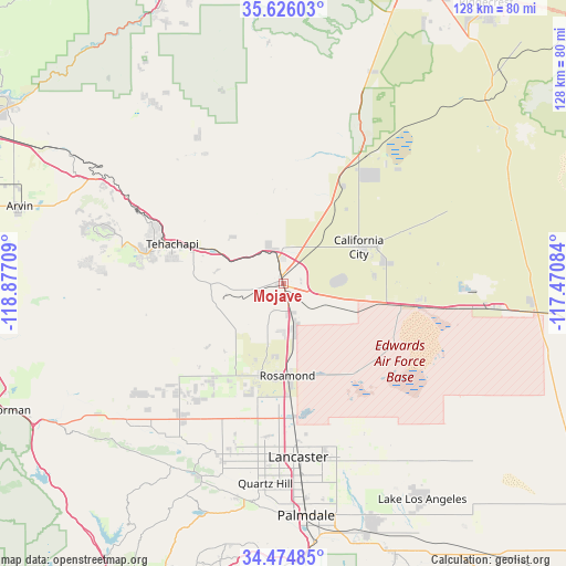
Mojave GPS coordinates[2]
35° 3' 8.892" North, 118° 10' 26.256" West
| Map corner | latitude | longitude |
|---|---|---|
| Upper-left | 35.62603°, | -118.87709° |
| Center: | 35.05247°, | -118.17396° |
| Lower-right: | 34.47485°, | -117.47084° |
| Map W x H: | 128×128 km | = 79.5×79.5mi |
| max Lat: | 71.29058° ⇑75.1% North |
| Mojave: | 35.05247° |
| min Lat: | ⇓24.9% South 19.06759° |
| min Long | Mojave | max Long |
| -171.73463° | -118.17396° | -66.98998° |
| W 8.9%⇐ | ⇒91.1% E |
Elevation
Elevation of Mojave is 843 m = 2766 ft, and this is 548.2 m = 1799 ft above average elevation for this country.
| Max E: |
3189 m = 10463 ft | 7.6% |
| Mojave | 843 m 2766 ft | |
| Avg. | 294.8 m = 967 ft | |
Min E: |
-60 m = -197 ft | 92.4% |
See also: United States elevation on elevation.city.
Geographical zone
Mojave is located in North temperate zone (between Tropic of Cancer and the Arctic Circle). Distance of this Northern Tropic circle is 1291.6 km =802.6 mi to South.| Distance of | km | miles | from Mojave |
|---|---|---|---|
| North Pole | 6109.6 | 3796.3 | to North |
| Arctic Circle | 3503.7 | 2177.1 | to North |
| Tropic Cancer | 1291.6 | 802.6 | to South |
| Equator | 3897.5 | 2421.8 | to South |


Nearby cities:
15 places around Mojave: (largest is in red/bold)
• Bear Valley Springs
43 km =26.7 mi,  286°
286°
• Boron
48.1 km =29.9 mi,  97°
97°
• California City
19 km =11.8 mi,  64°
64°
• Desert View Highlands
51.4 km =31.9 mi,  177°
177°
• Edwards Air Force Base
26.5 km =16.5 mi,  124°
124°
• Golden Hills
30.5 km =19 mi, 289°
• Green Valley
52.7 km =32.7 mi,  204°
204°
• Lake Hughes
48.5 km =30.1 mi,  210°
210°
• Lancaster
39.6 km =24.6 mi, 175°
• Leona Valley
49.4 km =30.7 mi,  192°
192°
• North Edwards
31.3 km =19.4 mi, 97°
• Quartz Hill
45.5 km =28.3 mi, 185°
• Rosamond
21 km =13 mi, 177°
• Stallion Springs
42.8 km =26.6 mi,  275°
275°
• Tehachapi
26.5 km =16.5 mi, 289°
Sources, notices
• [Note1] Compared only with cities in United States existing in our database
• [Src1] Map data: © OpenStreetMap contributors (CC-BY-SA)
• [Src2] Other city data from geonames.org with taken over terms of usage.
• [Src3] Geographical zone / Annual Mean Temperature by Robert A. Rohde @ Wikipedia
