Edwards Air Force Base geodata
Edwards Air Force Base (California) is a populated place; located in United States in America/Los_Angeles (GMT-7) time zone. With population of 2,063 people, there are 11746 cities with bigger population in this country. Compared to other cities in United States, 75.8% of cities are located further ↑North; 90.8% of cities are located further →East and 91.3% of cities have lower elevation than Edwards Air Force Base. Note1
Current local time in Edwards Air Force Base:
12:52 AM, WednesdayDifference from your time zone: hours


Edwards Air Force Base GPS coordinates[2]
34° 54' 58.932" North, 117° 56' 7.26" West
| Map corner | latitude | longitude |
|---|---|---|
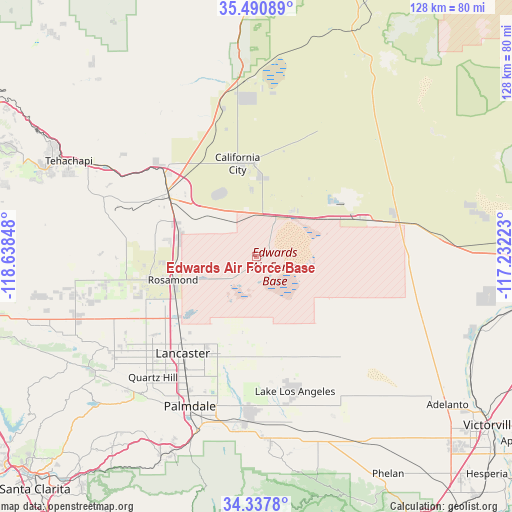
| Upper-left | 35.49089°, | -118.63848° |
| Center: | 34.91637°, | -117.93535° |
| Lower-right: | 34.3378°, | -117.23223° |
| Map W x H: | 128.2×128.2 km | = 79.7×79.7mi |
| max Lat: | 71.29058° ⇑75.8% North |
| Edwards Air Force Base: | 34.91637° |
| min Lat: | ⇓24.2% South 19.06759° |
| min Long | Edwards Air For | max Long |
| -171.73463° | -117.93535° | -66.98998° |
| W 9.2%⇐ | ⇒90.8% E |
Elevation
Elevation of Edwards Air Force Base is 731 m = 2398 ft, and this is 436.2 m = 1431 ft above average elevation for this country.
| Max E: |
3189 m = 10463 ft | 8.7% |
| Edwards Air Force Base | 731 m 2398 ft | |
| Avg. | 294.8 m = 967 ft | |
Min E: |
-60 m = -197 ft | 91.3% |
See also: United States elevation on elevation.city.
Geographical zone
Edwards Air Force Base is located in North temperate zone (between Tropic of Cancer and the Arctic Circle). Distance of this Northern Tropic circle is 1276.4 km =793.1 mi to South.| Distance of | km | miles | from Edwards Air Force Base |
|---|---|---|---|
| North Pole | 6124.7 | 3805.7 | to North |
| Arctic Circle | 3518.8 | 2186.5 | to North |
| Tropic Cancer | 1276.4 | 793.1 | to South |
| Equator | 3882.3 | 2412.3 | to South |


Nearby cities:
15 places around Edwards Air Force Base: (largest is in red/bold)
• Boron
27.6 km =17.1 mi,  70°
70°
• California City
23.7 km =14.7 mi,  348°
348°
• Desert View Highlands
41.3 km =25.7 mi,  208°
208°
• Lake Los Angeles
35.2 km =21.9 mi,  163°
163°
• Lancaster
30.5 km =19 mi,  217°
217°
• Leona Valley
46.2 km =28.7 mi, 224°
• Littlerock
44.2 km =27.5 mi,  185°
185°
• Mojave
26.5 km =16.5 mi,  304°
304°
• North Edwards
14.5 km =9 mi,  39°
39°
• Palmdale
41 km =25.5 mi,  203°
203°
• Quartz Hill
39.7 km =24.7 mi, 220°
• Rosamond
21.6 km =13.4 mi,  254°
254°
• Sun Village
39.7 km =24.7 mi,  182°
182°
• Tehachapi
52.6 km =32.7 mi, 297°
• Vincent
49.1 km =30.5 mi, 199°
In other languages:
- In Spanish: Base de la Fuerza Aérea Edwards
- In Russian: Эдвардс
- In Chinese: 爱德华兹空军基地
Sources, notices
• [Note1] Compared only with cities in United States existing in our database
• [Src1] Map data: © OpenStreetMap contributors (CC-BY-SA)
• [Src2] Other city data from geonames.org with taken over terms of usage.
• [Src3] Geographical zone / Annual Mean Temperature by Robert A. Rohde @ Wikipedia
