Patterson Tract geodata
Patterson Tract (California) is a populated place; located in United States in America/Los_Angeles (GMT-7) time zone. With population of 1,752 people, there are 12732 cities with bigger population in this country. Compared to other cities in United States, 68.6% of cities are located further ↑North; 92.2% of cities are located further →East and 69.7% of cities have higher elevation than Patterson Tract. Note1


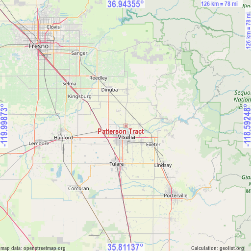
Patterson Tract GPS coordinates[2]
36° 22' 46.272" North, 119° 17' 44.16" West
| Map corner | latitude | longitude |
|---|---|---|
| Upper-left | 36.94355°, | -119.99873° |
| Center: | 36.37952°, | -119.2956° |
| Lower-right: | 35.81137°, | -118.59248° |
| Map W x H: | 125.9×125.9 km | = 78.2×78.2mi |
| max Lat: | 71.29058° ⇑68.6% North |
| Patterson Tract: | 36.37952° |
| min Lat: | ⇓31.4% South 19.06759° |
| min Long | Patterson Tract | max Long |
| -171.73463° | -119.2956° | -66.98998° |
| W 7.8%⇐ | ⇒92.2% E |
Elevation
Elevation of Patterson Tract is 102 m = 335 ft, and this is 192.8 m = 633 ft below average elevation for this country.
| Max E: |
3189 m = 10463 ft | 69.7% |
| Avg. | 294.8 m = 967 ft | |
| Patterson Tract | 102 m = 335 ft | |
Min E: |
-60 m = -197 ft | 30.3% |
See also: United States elevation on elevation.city.
Geographical zone
Patterson Tract is located in North temperate zone (between Tropic of Cancer and the Arctic Circle). Distance of this Northern Tropic circle is 1439.1 km =894.2 mi to South.| Distance of | km | miles | from Patterson Tract |
|---|---|---|---|
| North Pole | 5962 | 3704.6 | to North |
| Arctic Circle | 3356.2 | 2085.4 | to North |
| Tropic Cancer | 1439.1 | 894.2 | to South |
| Equator | 4045 | 2513.4 | to South |


Nearby cities:
15 places around Patterson Tract: (largest is in red/bold)
• Cutler
16 km =9.9 mi,  2°
2°
• Dinuba
20 km =12.4 mi,  335°
335°
• East Tulare Villa
19.6 km =12.2 mi,  176°
176°
• Exeter
16.6 km =10.3 mi,  124°
124°
• Farmersville
12.1 km =7.5 mi,  138°
138°
• Goshen
11.6 km =7.2 mi,  254°
254°
• Ivanhoe
7 km =4.3 mi,  83°
83°
• Linnell Camp
10.2 km =6.3 mi, 140°
• London
17 km =10.6 mi,  309°
309°
• Orosi
18.4 km =11.4 mi, 2°
• Sultana
18.9 km =11.7 mi,  347°
347°
• Traver
18.9 km =11.7 mi,  296°
296°
• Tulare
19.7 km =12.2 mi,  193°
193°
• Visalia
5.5 km =3.4 mi, 176°
• Woodlake
18 km =11.2 mi, 77°
Sources, notices
• [Note1] Compared only with cities in United States existing in our database
• [Src1] Map data: © OpenStreetMap contributors (CC-BY-SA)
• [Src2] Other city data from geonames.org with taken over terms of usage.
• [Src3] Geographical zone / Annual Mean Temperature by Robert A. Rohde @ Wikipedia
