Visalia geodata
Visalia (California) is a seat of a second-order administrative division; located in United States in America/Los_Angeles (GMT-7) time zone. With population of 130,104 people, there are 236 cities with bigger population in this country. Compared to other cities in United States, 68.8% of cities are located further ↑North; 92.2% of cities are located further →East and 68.5% of cities have higher elevation than Visalia. Note1


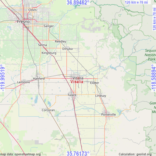
Visalia GPS coordinates[2]
36° 19' 48.828" North, 119° 17' 31.416" West
| Map corner | latitude | longitude |
|---|---|---|
| Upper-left | 36.89462°, | -119.99519° |
| Center: | 36.33023°, | -119.29206° |
| Lower-right: | 35.76173°, | -118.58894° |
| Map W x H: | 126×126 km | = 78.3×78.3mi |
| max Lat: | 71.29058° ⇑68.8% North |
| Visalia: | 36.33023° |
| min Lat: | ⇓31.2% South 19.06759° |
| min Long | Visalia | max Long |
| -171.73463° | -119.29206° | -66.98998° |
| W 7.8%⇐ | ⇒92.2% E |
Elevation
Elevation of Visalia is 110 m = 361 ft, and this is 184.8 m = 606 ft below average elevation for this country.
| Max E: |
3189 m = 10463 ft | 68.5% |
| Avg. | 294.8 m = 967 ft | |
| Visalia | 110 m = 361 ft | |
Min E: |
-60 m = -197 ft | 31.5% |
See also: Visalia elevation on elevation.city.
Geographical zone
Visalia is located in North temperate zone (between Tropic of Cancer and the Arctic Circle). Distance of this Northern Tropic circle is 1433.6 km =890.8 mi to South.| Distance of | km | miles | from Visalia |
|---|---|---|---|
| North Pole | 5967.5 | 3708 | to North |
| Arctic Circle | 3361.6 | 2088.8 | to North |
| Tropic Cancer | 1433.6 | 890.8 | to South |
| Equator | 4039.5 | 2510 | to South |


Nearby cities:
15 places around Visalia: (largest is in red/bold)
• Cutler
21.5 km =13.4 mi,  1°
1°
• East Tulare Villa
14.1 km =8.8 mi,  176°
176°
• Exeter
14 km =8.7 mi,  105°
105°
• Farmersville
8.5 km =5.3 mi,  115°
115°
• Goshen
11.7 km =7.3 mi,  281°
281°
• Ivanhoe
9.2 km =5.7 mi,  46°
46°
• Lindsay
23.1 km =14.4 mi,  127°
127°
• Linnell Camp
6.7 km =4.2 mi, 110°
• London
21.1 km =13.1 mi,  320°
320°
• Matheny
18.5 km =11.5 mi,  196°
196°
• Orosi
23.9 km =14.9 mi, 1°
• Patterson Tract
5.5 km =3.4 mi,  356°
356°
• Traver
22.2 km =13.8 mi,  308°
308°
• Tulare
14.5 km =9 mi, 199°
• Woodlake
19.6 km =12.2 mi,  61°
61°
Sources, notices
• [Note1] Compared only with cities in United States existing in our database
• [Src1] Map data: © OpenStreetMap contributors (CC-BY-SA)
• [Src2] Other city data from geonames.org with taken over terms of usage.
• [Src3] Geographical zone / Annual Mean Temperature by Robert A. Rohde @ Wikipedia
