Parlier geodata
Parlier (California) is a populated place; located in United States in America/Los_Angeles (GMT-7) time zone. With population of 15,138 people, there are 3217 cities with bigger population in this country. Compared to other cities in United States, 67.7% of cities are located further ↑North; 92.4% of cities are located further →East and 68.9% of cities have higher elevation than Parlier. Note1


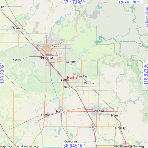
Parlier GPS coordinates[2]
36° 36' 41.832" North, 119° 31' 37.452" West
| Map corner | latitude | longitude |
|---|---|---|
| Upper-left | 37.17395°, | -120.2302° |
| Center: | 36.61162°, | -119.52707° |
| Lower-right: | 36.04516°, | -118.82395° |
| Map W x H: | 125.5×125.5 km | = 78×78mi |
| max Lat: | 71.29058° ⇑67.7% North |
| Parlier: | 36.61162° |
| min Lat: | ⇓32.3% South 19.06759° |
| min Long | Parlier | max Long |
| -171.73463° | -119.52707° | -66.98998° |
| W 7.6%⇐ | ⇒92.4% E |
Elevation
Elevation of Parlier is 107 m = 351 ft, and this is 187.8 m = 616 ft below average elevation for this country.
| Max E: |
3189 m = 10463 ft | 68.9% |
| Avg. | 294.8 m = 967 ft | |
| Parlier | 107 m = 351 ft | |
Min E: |
-60 m = -197 ft | 31.1% |
See also: United States elevation on elevation.city.
Geographical zone
Parlier is located in North temperate zone (between Tropic of Cancer and the Arctic Circle). Distance of this Northern Tropic circle is 1464.9 km =910.2 mi to South.| Distance of | km | miles | from Parlier |
|---|---|---|---|
| North Pole | 5936.2 | 3688.6 | to North |
| Arctic Circle | 3330.3 | 2069.4 | to North |
| Tropic Cancer | 1464.9 | 910.2 | to South |
| Equator | 4070.8 | 2529.5 | to South |


Nearby cities:
15 places around Parlier: (largest is in red/bold)
• Del Rey
8 km =5 mi,  311°
311°
• Dinuba
14.6 km =9.1 mi,  121°
121°
• Fowler
13.7 km =8.5 mi,  278°
278°
• Kingsburg
11.1 km =6.9 mi,  192°
192°
• London
16.8 km =10.4 mi,  153°
153°
• Malaga
20.1 km =12.5 mi,  293°
293°
• Minkler
13.9 km =8.6 mi,  26°
26°
• Orange Cove
19.1 km =11.9 mi,  85°
85°
• Orosi
22.7 km =14.1 mi,  109°
109°
• Reedley
7.1 km =4.4 mi,  103°
103°
• Sanger
11 km =6.8 mi,  346°
346°
• Selma
8.8 km =5.5 mi,  239°
239°
• Sultana
18.2 km =11.3 mi, 113°
• Sunnyside
21.7 km =13.5 mi, 314°
• Traver
17.8 km =11.1 mi,  167°
167°
Sources, notices
• [Note1] Compared only with cities in United States existing in our database
• [Src1] Map data: © OpenStreetMap contributors (CC-BY-SA)
• [Src2] Other city data from geonames.org with taken over terms of usage.
• [Src3] Geographical zone / Annual Mean Temperature by Robert A. Rohde @ Wikipedia
