Hartley geodata
Hartley (California) is a populated place; located in United States in America/Los_Angeles (GMT-7) time zone. With population of 2,510 people, there are 10586 cities with bigger population in this country. Compared to other cities in United States, 59.2% of cities are located further ↑North; 94.9% of cities are located further →East and 81.8% of cities have higher elevation than Hartley. Note1


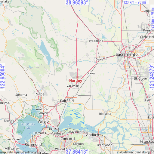
Hartley GPS coordinates[2]
38° 25' 1.668" North, 121° 56' 48.876" West
| Map corner | latitude | longitude |
|---|---|---|
| Upper-left | 38.96593°, | -122.65004° |
| Center: | 38.41713°, | -121.94691° |
| Lower-right: | 37.86413°, | -121.24379° |
| Map W x H: | 122.5×122.5 km | = 76.1×76.1mi |
| max Lat: | 71.29058° ⇑59.2% North |
| Hartley: | 38.41713° |
| min Lat: | ⇓40.8% South 19.06759° |
| min Long | Hartley | max Long |
| -171.73463° | -121.94691° | -66.98998° |
| W 5.1%⇐ | ⇒94.9% E |
Elevation
Elevation of Hartley is 39 m = 128 ft, and this is 255.8 m = 839 ft below average elevation for this country.
| Max E: |
3189 m = 10463 ft | 81.8% |
| Avg. | 294.8 m = 967 ft | |
| Hartley | 39 m = 128 ft | |
Min E: |
-60 m = -197 ft | 18.2% |
See also: United States elevation on elevation.city.
Geographical zone
Hartley is located in North temperate zone (between Tropic of Cancer and the Arctic Circle). Distance of this Northern Tropic circle is 1665.7 km =1035 mi to South.| Distance of | km | miles | from Hartley |
|---|---|---|---|
| North Pole | 5735.5 | 3563.9 | to North |
| Arctic Circle | 3129.6 | 1944.6 | to North |
| Tropic Cancer | 1665.7 | 1035 | to South |
| Equator | 4271.6 | 2654.2 | to South |


Nearby cities:
15 places around Hartley: (largest is in red/bold)
• Allendale
3.1 km =1.9 mi,  6°
6°
• Cottonwood
26.9 km =16.7 mi,  355°
355°
• Davis
22.9 km =14.2 mi,  51°
51°
• Dixon
11.2 km =7 mi,  73°
73°
• Esparto
31.2 km =19.4 mi,  348°
348°
• Fairfield
20.3 km =12.6 mi,  203°
203°
• Green Valley
26.2 km =16.3 mi,  225°
225°
• Madison
29.2 km =18.1 mi, 356°
• Monument Hills
28.2 km =17.5 mi, 12°
• Napa
32.4 km =20.1 mi,  245°
245°
• Rio Vista
35.7 km =22.2 mi,  142°
142°
• Suisun
21.5 km =13.4 mi, 202°
• Vacaville
7.6 km =4.7 mi,  207°
207°
• Winters
12.2 km =7.6 mi, 350°
• Woodland
32.8 km =20.4 mi,  27°
27°
Sources, notices
• [Note1] Compared only with cities in United States existing in our database
• [Src1] Map data: © OpenStreetMap contributors (CC-BY-SA)
• [Src2] Other city data from geonames.org with taken over terms of usage.
• [Src3] Geographical zone / Annual Mean Temperature by Robert A. Rohde @ Wikipedia
