Vacaville geodata
Vacaville (California) is a populated place; located in United States in America/Los_Angeles (GMT-7) time zone. With population of 96,803 people, there are 365 cities with bigger population in this country. Compared to other cities in United States, 59.6% of cities are located further ↑North; 95% of cities are located further →East and 78.2% of cities have higher elevation than Vacaville. Note1


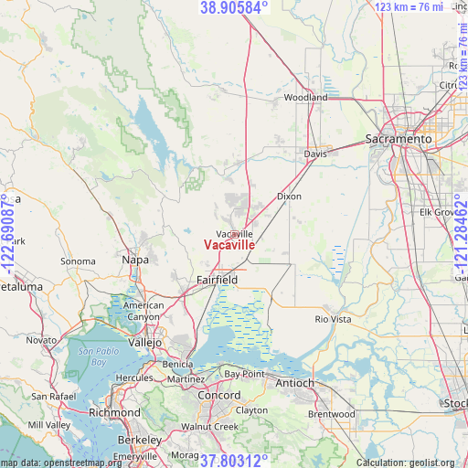
Vacaville GPS coordinates[2]
38° 21' 23.688" North, 121° 59' 15.864" West
| Map corner | latitude | longitude |
|---|---|---|
| Upper-left | 38.90584°, | -122.69087° |
| Center: | 38.35658°, | -121.98774° |
| Lower-right: | 37.80312°, | -121.28462° |
| Map W x H: | 122.6×122.6 km | = 76.2×76.2mi |
| max Lat: | 71.29058° ⇑59.6% North |
| Vacaville: | 38.35658° |
| min Lat: | ⇓40.4% South 19.06759° |
| min Long | Vacaville | max Long |
| -171.73463° | -121.98774° | -66.98998° |
| W 5%⇐ | ⇒95% E |
Elevation
Elevation of Vacaville is 55 m = 180 ft, and this is 239.8 m = 787 ft below average elevation for this country.
| Max E: |
3189 m = 10463 ft | 78.2% |
| Avg. | 294.8 m = 967 ft | |
| Vacaville | 55 m = 180 ft | |
Min E: |
-60 m = -197 ft | 21.8% |
See also: Vacaville elevation on elevation.city.
Geographical zone
Vacaville is located in North temperate zone (between Tropic of Cancer and the Arctic Circle). Distance of this Northern Tropic circle is 1658.9 km =1030.8 mi to South.| Distance of | km | miles | from Vacaville |
|---|---|---|---|
| North Pole | 5742.2 | 3568 | to North |
| Arctic Circle | 3136.3 | 1948.8 | to North |
| Tropic Cancer | 1658.9 | 1030.8 | to South |
| Equator | 4264.9 | 2650.1 | to South |


Nearby cities:
15 places around Vacaville: (largest is in red/bold)
• Allendale
10.5 km =6.5 mi,  21°
21°
• American Canyon
31.2 km =19.4 mi,  229°
229°
• Cottonwood
33.6 km =20.9 mi,  2°
2°
• Davis
30 km =18.6 mi,  45°
45°
• Dixon
17.4 km =10.8 mi,  55°
55°
• Fairfield
12.8 km =8 mi,  200°
200°
• Green Valley
19.1 km =11.9 mi, 232°
• Hartley
7.6 km =4.7 mi,  27°
27°
• Madison
35.9 km =22.3 mi, 2°
• Monument Hills
35.6 km =22.1 mi, 15°
• Napa
26.8 km =16.7 mi,  255°
255°
• Rio Vista
33.3 km =20.7 mi,  130°
130°
• Suisun
13.9 km =8.6 mi, 199°
• Winters
18.8 km =11.7 mi, 4°
• Yountville
32.9 km =20.4 mi,  278°
278°
Sources, notices
• [Note1] Compared only with cities in United States existing in our database
• [Src1] Map data: © OpenStreetMap contributors (CC-BY-SA)
• [Src2] Other city data from geonames.org with taken over terms of usage.
• [Src3] Geographical zone / Annual Mean Temperature by Robert A. Rohde @ Wikipedia
