Mira Mesa geodata
Mira Mesa (California) is a section of populated place; located in United States in America/Los_Angeles (GMT-7) time zone. With population of 70,000 people, there are 594 cities with bigger population in this country. Compared to other cities in United States, 85.5% of cities are located further ↑North; 89.9% of cities are located further →East and 63.5% of cities have higher elevation than Mira Mesa. Note1


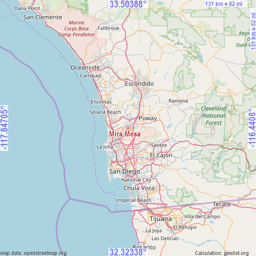
Mira Mesa GPS coordinates[2]
32° 54' 56.16" North, 117° 8' 38.112" West
| Map corner | latitude | longitude |
|---|---|---|
| Upper-left | 33.50388°, | -117.84705° |
| Center: | 32.9156°, | -117.14392° |
| Lower-right: | 32.32338°, | -116.4408° |
| Map W x H: | 131.3×131.3 km | = 81.6×81.6mi |
| max Lat: | 71.29058° ⇑85.5% North |
| Mira Mesa: | 32.9156° |
| min Lat: | ⇓14.5% South 19.06759° |
| min Long | Mira Mesa | max Long |
| -171.73463° | -117.14392° | -66.98998° |
| W 10.1%⇐ | ⇒89.9% E |
Elevation
Elevation of Mira Mesa is 136 m = 446 ft, and this is 158.8 m = 521 ft below average elevation for this country.
| Max E: |
3189 m = 10463 ft | 63.5% |
| Avg. | 294.8 m = 967 ft | |
| Mira Mesa | 136 m = 446 ft | |
Min E: |
-60 m = -197 ft | 36.5% |
See also: Mira Mesa elevation on elevation.city.
Geographical zone
Mira Mesa is located in North temperate zone (between Tropic of Cancer and the Arctic Circle). Distance of this Northern Tropic circle is 1054 km =654.9 mi to South.| Distance of | km | miles | from Mira Mesa |
|---|---|---|---|
| North Pole | 6347.2 | 3944 | to North |
| Arctic Circle | 3741.3 | 2324.7 | to North |
| Tropic Cancer | 1054 | 654.9 | to South |
| Equator | 3659.9 | 2274.2 | to South |


Nearby cities:
15 places around Mira Mesa: (largest is in red/bold)
• Del Mar
12.3 km =7.6 mi,  293°
293°
• El Cajon
21.6 km =13.4 mi,  128°
128°
• Encinitas
19.3 km =12 mi,  314°
314°
• Eucalyptus Hills
18.8 km =11.7 mi,  102°
102°
• Fairbanks Ranch
9.6 km =6 mi,  335°
335°
• La Jolla
14.3 km =8.9 mi,  238°
238°
• La Mesa
19.9 km =12.4 mi,  145°
145°
• Lakeside
21.7 km =13.5 mi,  107°
107°
• Poway
11.4 km =7.1 mi,  62°
62°
• Rancho Penasquitos
5.6 km =3.5 mi,  28°
28°
• Rancho Santa Fe
12.9 km =8 mi,  334°
334°
• Santee
18 km =11.2 mi,  118°
118°
• Solana Beach
14.5 km =9 mi, 305°
• Sorrento Valley
5 km =3.1 mi,  249°
249°
• Winter Gardens
21.8 km =13.5 mi, 115°
Sources, notices
• [Note1] Compared only with cities in United States existing in our database
• [Src1] Map data: © OpenStreetMap contributors (CC-BY-SA)
• [Src2] Other city data from geonames.org with taken over terms of usage.
• [Src3] Geographical zone / Annual Mean Temperature by Robert A. Rohde @ Wikipedia
