Sorrento Valley geodata
Sorrento Valley (California) is a section of populated place; located in United States in America/Los_Angeles (GMT-7) time zone. With population of 5,000 people, there are 7171 cities with bigger population in this country. Compared to other cities in United States, 85.5% of cities are located further ↑North; 90% of cities are located further →East and 70% of cities have higher elevation than Sorrento Valley. Note1


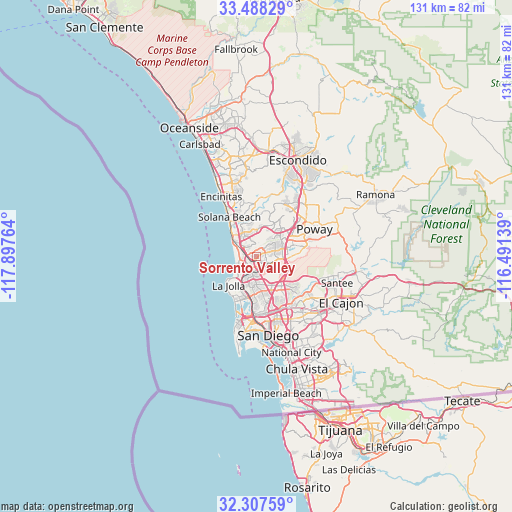
Sorrento Valley GPS coordinates[2]
32° 53' 59.676" North, 117° 11' 40.236" West
| Map corner | latitude | longitude |
|---|---|---|
| Upper-left | 33.48829°, | -117.89764° |
| Center: | 32.89991°, | -117.19451° |
| Lower-right: | 32.30759°, | -116.49139° |
| Map W x H: | 131.3×131.3 km | = 81.6×81.6mi |
| max Lat: | 71.29058° ⇑85.5% North |
| Sorrento Valley: | 32.89991° |
| min Lat: | ⇓14.5% South 19.06759° |
| min Long | Sorrento Valley | max Long |
| -171.73463° | -117.19451° | -66.98998° |
| W 10%⇐ | ⇒90% E |
Elevation
Elevation of Sorrento Valley is 101 m = 331 ft, and this is 193.8 m = 636 ft below average elevation for this country.
| Max E: |
3189 m = 10463 ft | 70% |
| Avg. | 294.8 m = 967 ft | |
| Sorrento Valley | 101 m = 331 ft | |
Min E: |
-60 m = -197 ft | 30% |
See also: United States elevation on elevation.city.
Geographical zone
Sorrento Valley is located in North temperate zone (between Tropic of Cancer and the Arctic Circle). Distance of this Northern Tropic circle is 1052.2 km =653.8 mi to South.| Distance of | km | miles | from Sorrento Valley |
|---|---|---|---|
| North Pole | 6348.9 | 3945 | to North |
| Arctic Circle | 3743 | 2325.8 | to North |
| Tropic Cancer | 1052.2 | 653.8 | to South |
| Equator | 3658.1 | 2273 | to South |


Nearby cities:
15 places around Sorrento Valley: (largest is in red/bold)
• Coronado
23.8 km =14.8 mi,  177°
177°
• Del Mar
9.4 km =5.8 mi,  315°
315°
• Encinitas
17.7 km =11 mi,  329°
329°
• Eucalyptus Hills
23.2 km =14.4 mi,  95°
95°
• Fairbanks Ranch
10.5 km =6.5 mi,  3°
3°
• La Jolla
9.5 km =5.9 mi,  231°
231°
• La Mesa
21.7 km =13.5 mi,  132°
132°
• Lemon Grove
23.2 km =14.4 mi,  138°
138°
• Mira Mesa
5 km =3.1 mi,  69°
69°
• Poway
16.4 km =10.2 mi,  64°
64°
• Rancho Penasquitos
9.9 km =6.2 mi,  48°
48°
• Rancho Santa Fe
13.4 km =8.3 mi,  356°
356°
• San Diego
20.7 km =12.9 mi,  172°
172°
• Santee
21.7 km =13.5 mi,  108°
108°
• Solana Beach
12.4 km =7.7 mi, 324°
Sources, notices
• [Note1] Compared only with cities in United States existing in our database
• [Src1] Map data: © OpenStreetMap contributors (CC-BY-SA)
• [Src2] Other city data from geonames.org with taken over terms of usage.
• [Src3] Geographical zone / Annual Mean Temperature by Robert A. Rohde @ Wikipedia
